La Niña ends
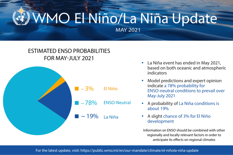
The 2020-2021 La Niña event has ended and neutral conditions (neither El Niño or La Niña) are likely to dominate the tropical Pacific in the next few months, according to the World Meteorological Organization (WMO). Air temperatures are expected to be above average between June and August, especially in the northern hemisphere.

There is a 78% chance of neutral conditions in the tropical Pacific until July, decreasing to 55% by August-October, and with more uncertainty for the rest of the calendar year, according to WMO’s El Niño/La Niña Update.
La Niña refers to the large-scale cooling of the ocean surface temperatures in the central and eastern equatorial Pacific Ocean, coupled with changes in the tropical atmospheric circulation, namely winds, pressure and rainfall. It usually has the opposite impacts on weather and climate as El Niño, which is the warm phase of the so-called El Niño Southern Oscillation (ENSO).
However, all naturally occurring climate events now take place in the context of human-induced climate change, which is increasing global temperatures, exacerbating extreme weather and impacting seasonal rainfall patterns.
“La Niña has a temporary global cooling effect, which is typically strongest in the second year of the event. This means that 2021 has got off to a relatively cool start – by recent standards. This should not lull us into a false sense of security that there is a pause in climate change,” said WMO Secretary-General Prof. Petteri Taalas.
“Carbon dioxide concentrations remain at record high levels and so will continue to drive global warming. According to new predictions issued by WMO, there is a 90% likelihood of at least one year between 2021-2025 becoming the warmest on record. This would dislodge 2016 – a strong El Niño year - from the top ranking,” said Prof. Taalas.
Global Seasonal Climate Update
El Niño and La Niña are major – but not the only - drivers of the Earth’s climate system.
In addition to the long-established ENSO Update, WMO now also issues regular Global Seasonal Climate Updates (GSCU), which incorporate influences of all other major climate drivers such as the North Atlantic Oscillation, the Arctic Oscillation and the Indian Ocean Dipole.
The Global Seasonal Climate Update is based on forecasts from WMO Global Producing Centres of Long-Range Forecasts and is used to support governments, the United Nations, decision-makers and stakeholders in climate sensitive sectors to mobilize preparations and protect lives and livelihoods.
Temperatures

|
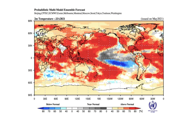
| Probabilistic forecasts of surface air temperature for June-August 2021. The tercile category with the highest forecast probability is indicated by shaded areas. The most likely category for below-normal, above-normal and near-normal is depicted in blue, red and grey shadings respectively. White areas indicate equal chances for all categories in both cases. The baseline period is 1993–2009. Figure is generated by The WMO Lead Centre for Long-Range Forecast Multi-Model Ensemble. |
The end of La Niña and widespread above average sea-surface temperatures because of global warming mean that air temperatures over land are forecast to be warmer than average from June to August 2021 over almost the whole northern hemisphere, in particular over the central western part of North America, the far northern part of Asia, part of central Asia, and far eastern Asia, the Arabian Peninsula and the northern Caribbean.
The Maritime subcontinent, along the south coast of West Africa, extending into central and eastern Africa and over eastern parts of South America are also forecast to see above average temperatures from June to August.
The only notable exceptions to the warmer-than-average trend are in north-western Europe, south Asia, and the northern part of South America, extending into the southern Caribbean, according to the Global Seasonal Climate Update.
The baseline period is 1993–2009.
Precipitation

|
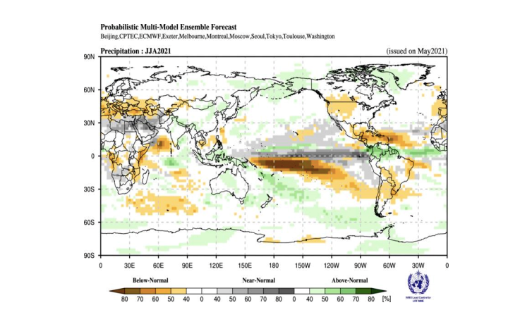
| Probabilistic forecasts of precipitation for the season for June-August 2021. The tercile category with the highest forecast probability is indicated by shaded areas. The most likely category for below-normal, above-normal and near-normal is depicted in orange, green and grey shadings respectively. White areas indicate equal chances for all categories in both cases. The baseline period is 1993–2009. Figure is generated by The WMO Lead Centre for Long-Range Forecast Multi-Model Ensemble |
Predicted rainfall patterns for June-August 2021 reflect the fact that there is neither a La Niña or El Niño event. Along the equator across most of the Pacific Ocean, probabilities are highest for near-normal rainfall.
There are increased chances of below-normal precipitation over the Caribbean, many parts of South America south of the equator, over much of the northern Mediterranean and South-eastern Europe, over parts of central and western North America, parts of Central Africa, and the east coast of Africa.
There is a moderate to high chance of above-normal rainfall over the northern parts of South America just to the north of the equator and in northern regions of the India subcontinent
The World Meteorological Organization is the United Nations System’s authoritative voice
on Weather, Climate and Water
For further information contact: Clare Nullis, media officer. Email cnullis wmo [dot] int (cnullis[at]wmo[dot]int). Cell 41797091397
Notes to Editors :
The WMO Global Seasonal Climate Update is based on an ensemble of global prediction models run by WMO-accredited centres around the world.
The WMO El Niño/La Niña Update is prepared through a collaborative effort between the WMO and the International Research Institute for Climate and Society (IRI), USA, and is based on contributions from experts worldwide.


