Global Seasonal Climate Update for May-June-July 2026
Observed Oceanic Drivers for the Previous Season
From January–March 2026 (JFM 2026), global sea-surface temperatures (SSTs) were generally above average, with the notable exception of the central and eastern equatorial Pacific.1 Above-average SSTs persisted across the extratropical oceans in both hemispheres. In the equatorial Pacific, near-average SSTs were consistent with ENSO-neutral conditions; however, a lingering and enhanced east–west SST gradient continued to sustain below-average rainfall anomalies near the Date Line and above-average rainfall anomalies to its west.
The Indian Ocean Dipole (IOD) remained near-average throughout the period. In the Atlantic basin, SSTs were generally above average, characterized by positive anomalies in both the North Tropical Atlantic (NTA) and South Tropical Atlantic (STA). Furthermore, above-normal SSTs persisted across the extratropical North Atlantic.

Outlook for Oceanic Drivers for the Next Season
For May–July 2026 (MJJ 2026), the Niño 3.4 plume indicates a rapid warming trend. Following the transition to neutral conditions in early 2026, the multi-model ensemble (MME) shows a nearly unanimous trajectory toward El Niño by May. By MJJ, the MME average approaches 1.5°C. The tight clustering of the models, despite the typical spring predictability barrier, underscores the high confidence in the onset of El Niño, followed by further intensification.
The IOD plume forecasts a shift from the near-average conditions observed in JFM toward a positive IOD phase. A majority of models indicate an index value exceeding +0.5°C by June/July 2026. This development, occurring in tandem with the El Niño onset, is expected to influence regional rainfall patterns. In the Atlantic, both the NTA and STA are projected to maintain slightly above-average SST values. The extratropical North Atlantic is also expected to remain warmer than normal, continuing the trend observed during the previous season.
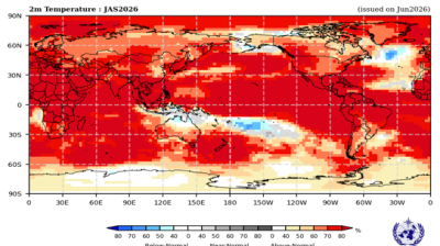
Surface Temperature Outlook for the Next Season
For the MJJ 2026 season, multi-model ensemble forecasts indicate a nearly global dominance of above-normal land surface temperatures. High probabilities (often exceeding 70–80%) are reinforced by strong model consistency, with most regions showing significant agreement for a positive anomaly.
Widespread tilts in probabilities for above-normal temperatures are forecast across the mid-latitudes. High model agreement is particularly robust over southern North America, Central America, and the Caribbean, where enhanced probabilities for above-normal temperatures remain in the highest tier. Europe and Northern Africa likewise show a strong signal for warmer-than-normal conditions. In northern North America and northern Asia, the tilt toward above-normal persists, though the probabilities are more moderate.
A strong enhancement in probabilities for above-normal temperatures continues across much of South America, with the highest consistency centered over the northern and central regions. For Australia, the outlook shows a moderate tilt in probabilities for above-normal temperatures, with moderate model agreement emerging in the west and south. A strong title in probabilities for above-normal temperature is also indicated over New Zealand. Southern Africa also shows an increased likelihood of above-normal temperatures.
The tropical belt is characterized by a strong and highly consistent tilt toward above-normal temperatures, particularly over Equatorial Africa and the Maritime Continent. In the oceans, the Equatorial Pacific east of the Date Line has extreme probabilities for above-normal SSTs, consistent with the rapid intensification of El Niño. Widespread warmth is also projected for the Indian Ocean and the tropical Atlantic. A notable exception remains in the North Atlantic, where a persistent horseshoe-like pattern of below- to near-normal probabilities straddles the warmer anomalies along 30°N.
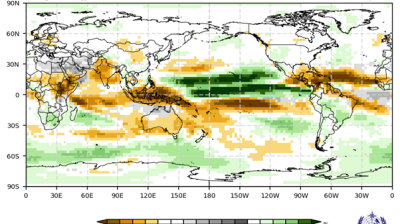
Rainfall Outlook for the Next Season
For the MJJ 2026 season, a strong and well-defined pattern is evident across the equatorial Pacific. A zonal band of enhanced probabilities for above-normal rainfall (exceeding 70–80%) extends north of the equator from 150°E to 150°W. This is flanked by enhanced probabilities for below-normal rainfall to the south and northeast. Over the Maritime Continent and the eastern Indian Ocean, a strong tilt in probability toward below-normal rainfall is forecast, supported by high model consistency.
In North America, most northern and central regions show no clear signal. A moderate tilt toward above-normal rainfall is forecast across Central America and parts of North America. Conversely, enhanced probabilities for below-normal rainfall are indicated for the southern Caribbean and the tropical North Atlantic. In South America, an enhanced probability for above-normal rainfall is predicted over the northwest, while parts of the central interior and the northeast (Nordeste) exhibit a tilt toward below-normal conditions.
Probabilities for above-normal rainfall are enhanced over the Arabian Peninsula, while the Indian subcontinent shows a weak to moderate enhancement in probabilities for below-normal rainfall. In Europe and Africa, the signal remains largely weak.
The forecast for Australia indicates a widespread tilt toward below-normal rainfall across the western, southern, and eastern portions of the continent. Model consistency is moderate to strong in the west.
1 https://www.cpc.ncep.noaa.gov/products/attribution/images/Attribution202603.pdf