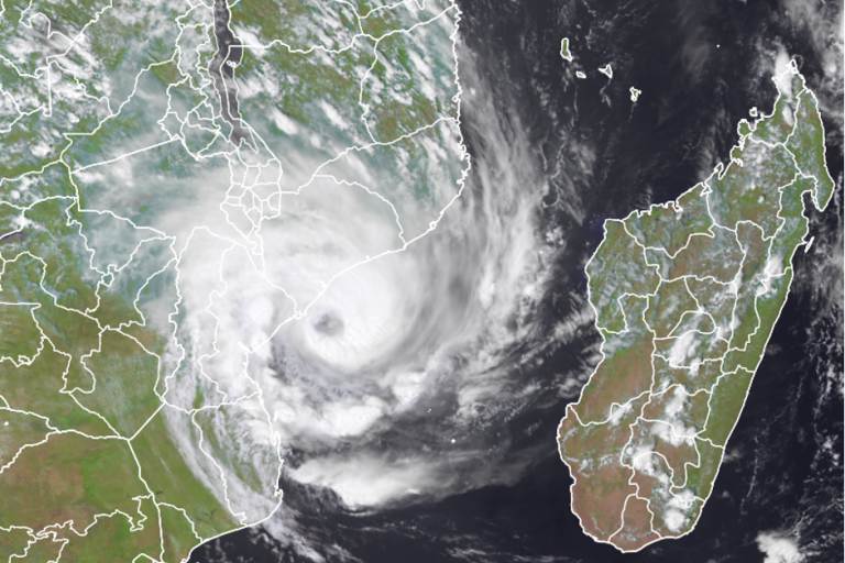
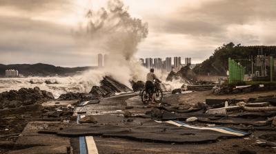
Tropical Cyclone Eloise hits Mozambique

Tropical Cyclone Eloise made landfall early morning on 23 January near Mozambique's city of Beira, causing widespread damage and flooding on a long swathe of coastline and impacting an area still recovering from Cyclone Idai. Neighbouring southern African nations are also being hit by torrential rainfall and flooding from Eloise, which weakened to a tropical storm after landfall.
Tropical Cyclone Eloise made landfall at Category 1 strength, with winds of 140 km/h and gusts up to 160 km/h, according to Mozambique’s National Institute of Meteorology (INAM) and WMO’s Regional Specialized Meteorological Centre La Réunion (MeteoFrance). Beira received 250 mm of rain in 24 hours, according to INAM. Other areas that were flooded ahead of Eloise’s landfall also received additional heavy rains.
Initial reports indicated that casualties were limited. A major humanitarian operation was launched, with relief agencies warning that flooding was the major threat. The tropical cyclone underlines once again the hazards posed by tropical cyclones and the importance of WMO’s efforts to strengthen early warnings and build resilience, especially in vulnerable countries on the frontline of climate change.
Eloise impacted Madagascar before crossing the Mozambican Channel, killing at least one person. RSMC La Réunion warned of heavy rains in parts of Zimbabwe, South Africa, Botswana, says WMO regional centre La Réunion. The South African Weather Service issued top-level Red Alerts as floods swept through the northern part of the country, including the famed Kruger National Park.

“Eloise poses a serious threat to the coast of Mozambique, and is dangerous cyclone, “according to RSMC La Reunion. “High winds, heavy rainfall and dangerous sea conditions are to be expected. There is a major risk of coastal flooding. »
«Inhabitants are urged to follow advice and warnings from local authorities, » it said.
Beira is still recovering from the devastation caused by Category 4 Cyclone Idai in March 2019. Ida was one of the worst tropical cyclones to hit Africa on record, claiming hundreds of lives, and affecting three million people across wide swaths of Mozambique, Madagascar, Malawi and Zimbabwe. Total property damages from Cyclone Idai have been estimated at some USD2.2 billion. Almost two years later, roughly 100,000 people remain in resettlement sites, which also have been battered by the recent rains.
Humanitarian agencies, including the World Food Programme and UN Children’s Fund mobilized contingency stocks in preparation.
The International Organization for Migration (IOM) said many people are already displaced in Beira City due to recent heavy rains and the impact of Tropical Storm Chalane which hit Sofala Province on 30 December.
Families were evacuated to two accommodation centres and tents provided by Mozambican disaster management authorities. After the experience of Idai, local residents spoke of their sense of fear and dread. “People who have moved to the accommodation centres are asking our staff, over and over again, “Why us? What have we done to deserve this?” said IOM.
Hazards

It has already been raining heavily along the Zambezi Basin. The probability of 300 -500 mm in 48 hours exacerbated existing flooding.
Zimbabwe, Botswana and North of South Africa are also impacted. There has already been significant rainfall in recent weeks in Botswana (dams are full). Botswana and Zimbabwe had a very active start of their rainy season, due to La Niña event.
A storm surge of about 1.5 m on average was forecast for the coast, which may reach 2 to 3.5 m locally, especially south of Beira near the Pungwe river. Given that Beira is a low-lying city, storm surge and coastal flooding pose a major hazard. In addition, although the astronomical tide has currently low coefficient, the high tide at 00 UTC could be an aggravating factor. The Maximum of the storm surge should impact south of Beira, on the other side of the river mouth (and not the mouth of the river in Beira, as for Idai), according to models issued by RSMC La Reunion.
Seasonal Forecast
The seasonal forecast of tropical cyclone activity in the South-West Indian Ocean for cyclone season 2020-2021(RSMC La Reunion) predicted that the 2020-2021 cyclone season is expected to be characterized by near to above normal activity in the Southwest Indian Ocean cyclone basin. This season could therefore see a total of between 9 and 12 systems (tropical storms and cyclones), with slightly more than half of them (between 5 and 7) reaching the tropical cyclone stage. “Let us recall that for a given place, only one system is needed to experience an impact that could be catastrophic”, stressed the seasonal forecast.
Resilience
WMO is supporting countries in the region to strengthen resilience and climate change adaptation.
South West Indian Ocean countries have launched a new five-year project to improve operational forecasting and multi-hazard early warning systems in a region which is exposed to climate change, sea level rise and extreme weather and has suffered an increase in the frequency and intensity of climate-related shocks in recent decades.
The project seeks to enhance early warning capacities in Comoros, Madagascar, Mauritius, Mozambique and Seychelles. The Climate Risk and Early Warning Systems (CREWS) initiative announced a US$ 4 million contribution, which will leverage upon wider ongoing and planned projects in the sub-region. It embraces the paradigm shift from what the weather will be to what the weather will do.
Following the devastating 2019 Tropical Cyclone season, a WMO fact-finding mission reported on immediate reconstruction needs for INAM, the Institute for Meteorology in Mozambique. The WMO Secretary-General presented this report at the Post Disaster Needs Assessment conference (PDNA) highlighting that equipment was needed to re-establish and upgrade INAM’s observations network and forecasting platform to support improved impact-based early warnings.
With finance from the World Bank, the Nordic Development fund and additional commitments under the PDNA by the African Development Bank and the Chinese International Development Agency, INAM is working with the UK Met Office, Met Norway and Deltares under a Technical Assistance Programme where procurement is already underway to support the development of the improved early warning system.
- WMO Member:
- Mozambique ,
- Zimbabwe ,
- South Africa ,
- Botswana ,
- France ,
- Madagascar ,
- Malawi


