April: high CO2, low sea ice and extreme weather
April 2018 was the third warmest on record, continuing the trend of above-average temperatures that has persisted for most of this century, according to data from the European Centre for Medium Range Weather Forecasts’ Copernicus Climate Change Service. There were also notable developments in long-term climate change indicators, including carbon dioxide levels and sea ice cover. April 2018 was marked by a number of high-impact weather events. These continued into early May with violent storms combining dust, high winds, lightning and rain that killed more than 100 people and injured about 300 in the Indian states of Uttar Pradesh and Rajasthan.

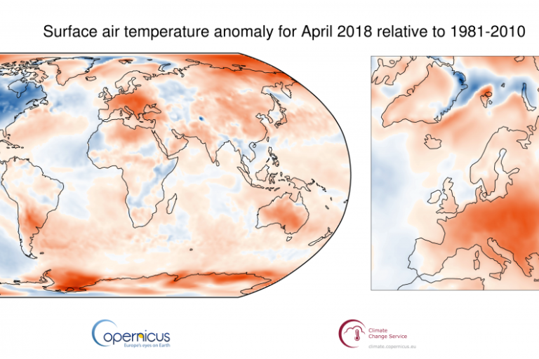
April 2018 was the third warmest on record, continuing the trend of above-average temperatures that has persisted for most of this century, according to data from the European Centre for Medium Range Weather Forecasts’ Copernicus Climate Change Service.
There were also notable developments in long-term climate change indicators, including carbon dioxide levels and sea ice cover.
April 2018 was marked by a number of high-impact weather events. These continued into early May with violent storms combining dust, high winds, lightning and rain that killed more than 100 people and injured about 300 in the Indian states of Uttar Pradesh and Rajasthan.
Storms are common in the pre-monsoon season in India, and the India Meteorological Department issued regular warnings. But the impact of the 2 May event was exceptional. High temperatures also were conducive to the severity of the dust storm, with intense heating taking place over the plains of northwest India, according to the India Meteorological Department. Parts of Rajasthan witnessed temperatures above 40°C, with maximum temperatures appreciably (3.1°C to 5.0°C) above normal.
Pakistan heatwave
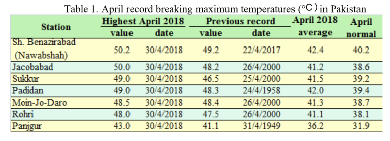
Two meteorological stations in Pakistan reported temperatures of at least 50° Celsius on 30 April at the peak of a heatwave in large parts of the country’s populous Sindh Province.
The persistent heat in the lower half of Pakistan started in March, when 30 sites broke monthly temperature records. Another exceptional hot spell affected the country in mid-April and peaked on 29 and 30 April when many records were set over large parts of Sindh Province, according to the Pakistan Meteorological Department. The PMD site Shaheed Benazirabad (Nawabshah) recorded a new national temperature record for April of 50.2 °C.

WMO’s official Archive of Weather and Climate Extremes does not validate monthly records. But it is the first time that it has ever received a report of a temperature topping 50°C in April. A temperature of 50.0°C was recorded on the same day at Jacobabad, and five other stations also reported new April records. PMD has forecast above average temperatures for the coming two months and has established a heat wave early warning centre in Karachi, the capital of Sindh and Pakistan’s most populous city.
Global temperatures
The global temperature for April 2018 was well above average. Although not as exceptional as the values for April 2016 and April 2017, it was in line with the upward trend of 0.18°C per decade seen in global temperature data from 1979 onwards. according to the Copernicus Climate Change report. Globally, the twelve-month period from May 2017 to April 2018 was 0.47°C warmer than the 1981-2010 average.
It said that April in 2018 was:
- close to 0.5°C warmer than the average April from 1981-2010;
- the third warmest April on record, though only a little warmer than April 2010;
- about 0.2°C cooler than the warmest April (2016).
It was the hottest April on record for a number of countries, including Argentina and Germany. Germany’s average temperature of 12.4°C was 4.0°C above the 1981-2010 baseline, according to the German Weather Service. Other areas of markedly above-average temperature include parts of Mexico and the American Southwest and much of North Africa, China and Mongolia.
Conversely, the month was considerably colder than average over the central USA and much of Canada. A number of other land regions had temperatures that were a little below average.
Heavy precipitation
Extreme and unusual weather impacted many parts of the world, including above-average seasonal rainfall and flooding in the East and Horn of Africa. Flash floods and river flooding has affected hundreds of thousands of people and killed dozens in Ethiopia, Kenya, Somalia, Tanzania and Uganda, according to the UN Office for Humanitarian Affairs.
During a 24-hour period between April 14 and 15, 49.69 inches (1,262 mm) of rain was reported measured at a rain gauge in Kauai, Hawaii. If verified by the US National Climatic Extremes Committee, it would be the heaviest 24-hour rainfall total ever recorded in the USA.
Extreme events are part of the natural variability of the climate, but heatwaves and heavy precipitation, in particular, are expected to increase because of climate change.
Long-term climate change indicators

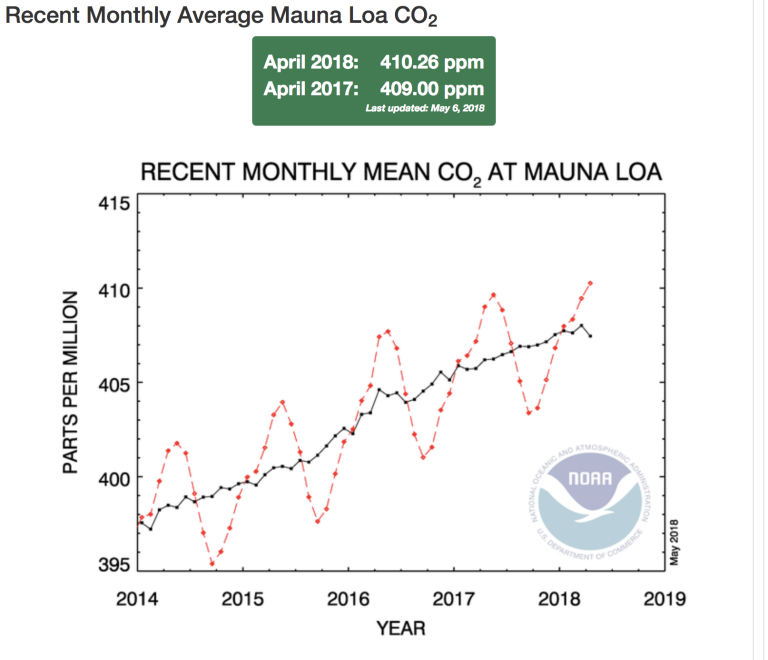
The average monthly concentration of carbon dioxide in the atmosphere at Mauna Loa Observatory in Hawaii for the first time in recorded history was above 410 parts per million in April, reaching 410.26 ppm, according to preliminary data from the US National Oceanic and Atmospheric Administration. Mauna Loa Observatory is the oldest continuous atmospheric measurement station in the world and is widely regarded as a benchmark site in the World Meteorological Organization's Global Atmosphere Watch network.
Spain’s Izaña observing station in Tenerife reported a new record concentration of carbon dioxide of nearly 414 ppm on 7 April.
WMO’s Global Atmosphere Watch monitoring stations in the northern hemisphere traditionally report peak concentrations in spring before the growth of vegetation which absorbs CO2. Despite the seasonal fluctuations, the underlying trend in greenhouse gas concentrations remains upward.
Much of the Arctic Ocean and some neighbouring land areas were again substantially warmer than the 1981-2010 average and Arctic sea ice extent was well below average. In particular, ice cover in the Bering Sea was record low at the end of April. Situated at the northern edge of the Pacific Ocean, the Bering Sea connects to the Arctic Ocean through the Bering Strait. “It’s the end of April and basically the Bering Sea is ice-free, when normally there would be more than 500,000 square kilometers of ice,” said the US National Snow and Ice Data Center. Total ice extent over the Arctic Ocean also remains low and consists of a record-high amount of first-year ice. This means the ice cover is unusually thin and large areas are susceptible to melting out in this coming summer, according to NSIDC.
Greenhouse gas concentrations, ice cover and global temperatures are all indicators of long-term climate change as a result of human activities. WMO’s annual statement on the State of the Climate in 2017 said that global mean temperatures in 2017 were about 1.1 °C above pre-industrial temperatures. The five-year average 2013–2017 global temperature is the highest five-year average on record. The world’s nine warmest years have all occurred since 2005, and the five warmest since 2010.


