HydroSOS seeks to improve water information

The WMO Global Hydrological Status and Outlook System (HydroSOS) aims to build a trusted operational global system capable of assessing the current status of surface and groundwater hydrological systems, and predicting how they will change continuously.
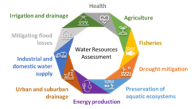
The WMO HydroSOS will be designed for, and will be operated by, National Hydrological Services, which will enable them to better support a range of stakeholders (including, government bodies, regional and international aid agencies, and the general public) in decision making related to water management.
 Water challenges already affect tens of millions of people with estimated costs in the order of magnitude of billions of US dollars, and are expected to intensify with future climate change, population growth and increasing economic activities.
WMO HydroSOS will be a worldwide operational framework bringing together: national, regional and global appraisals of where the current hydrological situation is significantly different from ‘‘normal’’ and regular assessments of whether conditions are likely to get better or worse in hydrological value chain.
HydroSOS will build capacity to undertake hydrological status assessments and outlooks within National Hydrological Services and directly draw on existing and planned WMO initiatives in relation to hydrological monitoring, data sharing and sub-seasonal to seasonal meteorological forecasting, together with different partners.
From November 11 to 14, National Hydrological Services and partners from basin organizations, regional climate centers and academia joined together in Nanjing, China, to define the way forward of the WMO HydroSOS.
Two pilot basins, the Lake Victoria and Ganges-Brahmaputra-Meghna, were selected based on a first assessment of identified priority needs, willingness to collaborate and existing cooperation mechanisms.
Other basins and regions will be welcomed. The WMO HydroSOS will improve cooperation among countries, creating a better understanding of the water resources, thanks a new approach for creating data and model products at global, regional and national scales.
HydroSOS will leverage existing global and regional data platforms and models to prepare tailored products according to user needs. The HydroSOS will be linked with other WMO hydrological forecasting initiatives with the long-term aim of supporting continuous seamless forecasting by national hydrological Services.
Meeting participants agreed on a roadmap for the initiative including the development of technical standards and a demonstration web-portal which will integrate hydrological services from WMO Member States. First public results are expected in June 2021.


