Climate change indicators and impacts worsened in 2020
Extreme weather combined with COVID-19 in a double blow for millions of people in 2020. However, the pandemic-related economic slowdown failed to put a brake on climate change drivers and accelerating impacts, according to a new report compiled by the World Meteorological Organization (WMO) and an extensive network of partners.

2020 was one of three warmest years on record, despite cooling La Niña
Extreme weather and COVID-19 combined in a double blow
New York/Geneva, 19 April 2021 (WMO) - Extreme weather combined with COVID-19 in a double blow for millions of people in 2020. However, the pandemic-related economic slowdown failed to put a brake on climate change drivers and accelerating impacts, according to a new report compiled by the World Meteorological Organization (WMO) and an extensive network of partners.
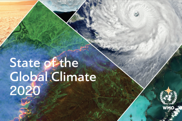
The report on the State of the Global Climate 2020 documents indicators of the climate system, including greenhouse gas concentrations, increasing land and ocean temperatures, sea level rise, melting ice and glacier retreat and extreme weather. It also highlights impacts on socio-economic development, migration and displacement, food security and land and marine ecosystems.
2020 was one of the three warmest years on record, despite a cooling La Niña event. The global average temperature was about 1.2° Celsius above the pre-industrial (1850-1900) level. The six years since 2015 have been the warmest on record. 2011-2020 was the warmest decade on record.
“It has been 28 years since the World Meteorological Organization issued the first state of the climate report in 1993, due to the concerns raised at that time about projected climate change. While understanding of the climate system and computing power have increased since then, the basic message remains the same and we now have 28 more years of data that show significant temperature increases over land and sea as well as other changes like sea level rise, melting of sea ice and glaciers and changes in precipitation patterns. This underscores the robustness of climate science based on the physical laws governing the behaviour of the climate system,” said WMO Secretary-General Prof. Petteri Taalas.
“All key climate indicators and associated impact information provided in this report highlight relentless, continuing climate change, an increasing occurrence and intensification of extreme events, and severe losses and damage, affecting people, societies and economies. The negative trend in climate will continue for the coming decades independent of our success in mitigation. It is therefore important to invest in adaptation. One of the most powerful ways to adapt is to invest in early warning services and weather observing networks. Several less developed countries have major gaps in their observing systems and are lacking state of the art weather, climate and water services.” said Prof. Taalas.
Prof. Taalas joined United Nations Secretary-General António Guterres in launching WMO’s flagship report at a press conference on 19 April. It comes ahead of the 22-23 April virtual Leaders Summit on Climate, convened by the United States of America. President Biden is seeking to galvanize efforts by the major economies to reduce greenhouse gas emissions and meet the targets of the Paris Agreement on Climate Change to keep temperature increase to well below 2°C above pre-industrial levels by the end of the century, and to 1.5°C if possible.
“This report shows that we have no time to waste. The climate is changing, and the impacts are already too costly for people and the planet. This is the year for action. Countries need to commit to net zero emissions by 2050. They need to submit, well ahead of COP26 in Glasgow, ambitious national climate plans that will collectively cut global emissions by 45 per cent compared to 2010 levels by 2030. And they need to act now to protect people against the disastrous effects of climate change,” said the UN Secretary-General.

In 2020, COVID-19 added a new and unwelcome dimension to weather, climate and water-related hazards, with wide-ranging combined impacts on human health and well-being. Mobility restrictions, economic downturns and disruptions to the agricultural sector exacerbated the effects of extreme weather and climate events along the entire food supply chain, elevating levels of food insecurity and slowing the delivery of humanitarian assistance. The pandemic also disrupted weather observations and complicated disaster risk reduction efforts.
The report illustrates how climate change poses a risk to the achievement of many of the Sustainable Development Goals, through a cascading chain of interrelated events. These can contribute to reinforcing or worsening existing inequalities. In addition, there is the potential for feedback loops which threaten to perpetuate the vicious cycle of climate change.
Information used in this report is sourced from a large number of National Meteorological and Hydrological Services and associated institutions, as well as Regional Climate Centres. UN partners include the Food and Agriculture Organization of the United Nations (FAO), International Monetary Fund (IMF), Intergovernmental Oceanographic Commission of UNESCO (IOC-UNESCO), International Organization for Migration (IOM), the United Nations Environment Programme (UNEP), UN High Commissioner for Refugees (UNHCR), the World Food Programme (WFP) and the World Health Organization.
It updates a provisional version released in December 2020 and is accompanied by a story map on global climate indicators.
Greenhouse Gases
Concentrations of the major greenhouse gases continued to increase in 2019 and 2020. Globally averaged mole fractions of carbon dioxide (CO2) have already exceeded 410 parts per million (ppm), and if the CO2 concentration follows the same pattern as in previous years, it could reach or exceed 414 ppm in 2021, according to the report. The economic slowdown temporarily depressed new greenhouse gas emissions, according to UNEP, but had no discernible impact on atmospheric concentrations.
The Ocean
The ocean absorbs around 23% of the annual emissions of anthropogenic CO2 into the atmosphere and acts as a buffer against climate change. However, the CO2 reacts with seawater, lowering its pH and leading to ocean acidification. This in turn reduces its capacity to absorb CO2 from the atmosphere. Ocean acidification and deoxygenation have continued, impacting ecosystems, marine life and fisheries, according to IOC-UNESCO.
The ocean also absorbs more than 90% of the excess heat from human activities. 2019 saw the highest ocean heat content on record, and this trend likely continued in 2020. The rate of ocean warming over the past decade was higher than the long-term average, indicating a continued uptake of heat trapped by greenhouse gases, according to the EU’s Copernicus Marine Service.
Over 80% of the ocean area experienced at least one marine heatwave in 2020. The percentage of the ocean that experienced “strong” marine heat waves (45%) was greater than that which experienced “moderate” marine heat waves (28%).

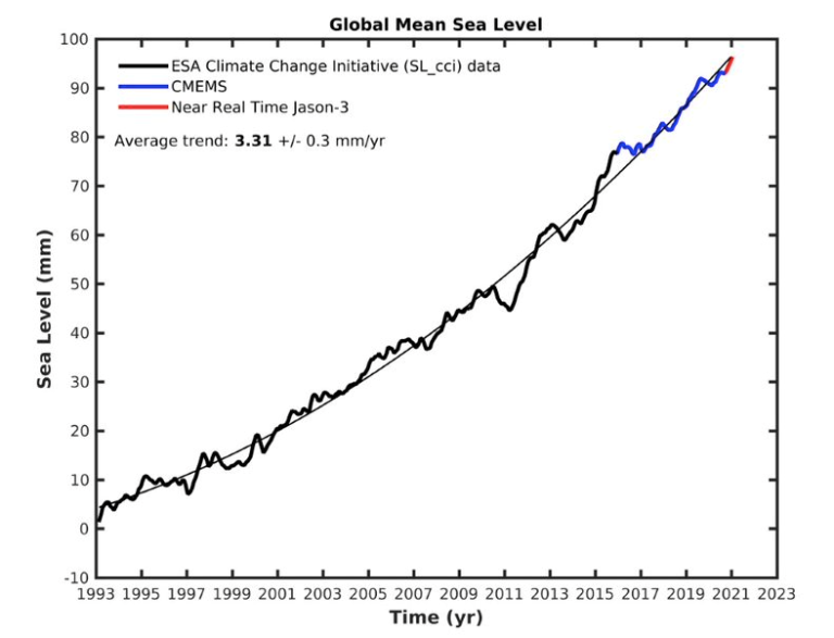
Global mean sea level has risen throughout the satellite altimeter record (since 1993). It has recently been rising at a higher rate partly due to the increased melting of the ice sheets in Greenland and Antarctica. A small drop in global mean sea level in the summer of 2020 was likely associated with developing La Niña conditions. Overall, global mean sea level continued to increase in 2020.
The Cryosphere
Since the mid-1980s, Arctic surface air temperatures have warmed at least twice as fast as the global average. This has potentially large implications not only for Arctic ecosystems, but also for the global climate through various feedbacks such as thawing permafrost releasing methane into the atmosphere.
The 2020 Arctic sea-ice extent minimum after the summer melt was 3.74 million km2, marking only the second time on record that it shrank to less than 4 million km2. Record low sea-ice extents were observed in the months of July and October. Record high temperatures north of the Arctic Circle in Siberia triggered an acceleration of sea-ice melt in the East Siberian and Laptev Seas, which saw a prolonged marine heatwave. The sea-ice retreat during the summer 2020 in the Laptev Sea was the earliest observed in the satellite era.
The Greenland ice sheet continued to lose mass. Although the surface mass balance was close to the long-term average, the loss of ice due to iceberg calving was at the high end of the 40-year satellite record. In total, approximately 152 Gt of ice were lost from the Greenland ice sheet between September 2019 and August 2020.
The Antarctic sea-ice extent remained close to the long-term average. However, the Antarctic ice sheet has exhibited a strong mass loss trend since the late 1990s. This trend accelerated around 2005, and currently, Antarctica loses approximately 175 to 225 Gt per year, due to the increasing flow rates of major glaciers in West Antarctica and the Antarctic Peninsula.
A loss of 200 Gt of ice per year corresponds to about twice the annual discharge of the river Rhine in Europe.

Floods and drought
Heavy rain and extensive flooding occurred over large parts of Africa and Asia in 2020. Heavy rain and flooding affected much of the Sahel and the Greater Horn of Africa, triggering a desert locust outbreak. The Indian subcontinent and neighbouring areas, China, the Republic of Korea and Japan, and parts of South-East Asia also received abnormally high rainfall at various times of the year.
Severe drought affected many parts of the interior of South America in 2020, with the worst-affected areas being northern Argentina, Paraguay and the western border areas of Brazil. The estimated agricultural losses were near US$ 3 billion in Brazil, with additional losses in Argentina, Uruguay and Paraguay.
Long-term drought continued to persist in parts of southern Africa, particularly the Northern and Eastern Cape Provinces of South Africa, although winter rains helped in the continuing recovery from the extreme drought situation which peaked in 2018.
Heat and fire
In a large region of the Siberian Arctic, temperatures in 2020 were more than 3°C above average, with a record temperature of 38°C in the town of Verkhoyansk. This was accompanied by prolonged and widespread wildfires.
In the USA, the largest fires ever recorded occurred in late summer and autumn. Widespread drought contributed to the fires, and July to September were the hottest and driest on record for the southwest. Death Valley in California reached 54.4°C on 16 August, the highest known temperature in the world in at least the last 80 years.
In the Caribbean, major heatwaves occurred in April and September. Cuba saw a new national temperature record of 39.7°C on 12 April. Further extreme heat in September saw national or territorial records set for Dominica, Grenada and Puerto Rico.
Australia broke heat records in early 2020, including the highest observed temperature in an Australian metropolitan area, in western Sydney, when Penrith reached 48.9°C.
The summer was very hot in parts of East Asia. Hamamatsu (41.1°C) equalled Japan’s national record on 17 August.
Europe experienced drought and heatwaves during summer 2020, although these were generally not as intense at in 2018 and 2019. In the eastern Mediterranean with all-time records set in Jerusalem (42.7°C) and Eilat (48.9°C) on 4 September, following a late July heatwave in the Middle East in which Kuwait Airport reached 52.1°C and Baghdad 51.8°C.
Tropical Cyclones

With 30 named storms, the 2020 North Atlantic hurricane season had its largest number of named storms on record. There were a record 12 landfalls in the United States of America, breaking the previous record of nine. Hurricane Laura reached category 4 intensity and made landfall on 27 August in western Louisiana, leading to extensive damage and US$ 19 billion in economic losses. Laura was also associated with extensive flood damage in Haiti and the Dominican Republic in its developing phase.
The last storm of the season, Iota, was also the most intense, reaching category 5 before landfall in Central America.
Cyclone Amphan which made landfall on 20 May near the India-Bangladesh border was the costliest tropical cyclone on record for the North Indian Ocean, with reported economic losses in India of approximately US$14 billion.
The strongest tropical cyclone of the season was Typhoon Goni (Rolly). It crossed the northern Philippines on 1 November with a 10-minute mean wind speed of 220 km/h (or higher) at its initial landfall, making it one of the most intense landfalls on record.
Tropical Cyclone Harold had significant impacts in the northern islands of Vanuatu on 6 April, affecting about 65% of the population and also resulting in damage in Fiji, Tonga and the Solomon Islands.
Storm Alex in early October brought extreme winds to western France with gusts as high as 186 km/h, whilst heavy rain extended across a wide area. 3 October was the wettest area- averaged day on record for the United Kingdom with a national average of 31.7 mm, whilst extreme rainfall occurred near the Mediterranean coast on both sides of the France-Italy border, with 24‑hour totals exceeding 600 mm in Italy and 500 mm in France.
Other major severe storms included a hailstorm in Calgary (Canada) on 13 June, with insured losses exceeding US$ 1 billion and a hailstorm in Tripoli (Libya) on 27 October, with hailstones as large as 20 cm, accompanied by unusually cold conditions.
COVID-19 impacts
More than 50 million people were doubly hit in 2020 by climate-related disasters (floods, droughts and storms) and by the COVID-19 pandemic, according to the International Federation of Red Cross and Red Crescent Societies. This worsened food insecurity and added another layer of risk to evacuation, recovery and relief operations related to high-impact events.
Cyclone Harold, which struck Fiji, the Solomon Islands, Tonga and Vanuatu and was one of the strongest storms ever recorded in the South Pacific, triggered an estimated 99 500 displacements. Because of COVID-19 lockdowns and quarantines, response and recovery operations were hampered leading to delays in providing equipment and assistance
In the Philippines, although over 180 000 people were pre-emptively evacuated ahead of Tropical Cyclone Vongfong (Ambo) in mid-May, the need for social distancing measures meant that residents could not be transported in large numbers and evacuation centres could only be used at half capacity.
In northern Central America, some 5.3 million people were in need of humanitarian assistance, including 560 000 internally displaced people before the onset of the pandemic. Responses to hurricanes Eta and Iota therefore took place in the context of complex, interlinked vulnerabilities.
Food insecurity

After decades of decline, the increase in food insecurity since 2014 is being driven by conflict and economic slowdown as well as climate variability and extreme weather events. Nearly 690 million people, or 9% of the world population, were undernourished, and about 750 million, or nearly 10%, were exposed to severe levels of food insecurity in 2019. Between 2008 and 2018, the impacts of disasters cost the agricultural sectors of developing country economies over $108 billion in damaged or lost crop and livestock production. The number of people classified under crisis, emergency and famine conditions had increased to almost 135 million people across 55 countries in 2019, according to FAO and WFP.
The effects of the COVID-19 pandemic crippled agriculture and food systems, inverting development trajectories and stunting economic growth. In 2020, the pandemic affected directly food supply and demand, with disruptions in the local, national and global supply chains, compromising access to farm inputs, resources and services needed to sustain agricultural productivity and ensure food security. As a result of the movement restrictions compounded by climate related disasters, significant challenges were posed for managing food insecurity worldwide, according to FAO.
Displacement
Over the past decade (2010–2019), weather-related events triggered an estimated 23.1 million displacements of people on average each year, most of them within national borders, according to the Internal Displacement Monitoring Centre. Some 9.8 million displacements, largely due to hydrometeorological hazards and disasters, were recorded during the first half of 2020, mainly concentrated in South and South-East Asia and the Horn of Africa.
Events in the second half of the year, including displacements linked to flooding across the Sahel region, the active Atlantic hurricane season, and typhoon impacts in South-East Asia, are expected to bring the total for the year close to the average for the decade.
According to IOM and UNHCR, many displacement situations triggered by hydrometeorological events have become prolonged or protracted for people unable to return to their former homes or without options for integrating locally or settling elsewhere. They may also be subject to repeated and frequent displacement, leaving little time for recovery between one shock and the next.
Lessons and opportunities for enhancing climate action
According to the International Monetary Fund, while the current global recession caused by the COVID-19 pandemic may make it challenging to enact the policies needed for mitigation, it also presents opportunities to set the economy on a greener path by boosting investment in green and resilient public infrastructure, thus supporting GDP and employment during the recovery phase.
Adaptation policies aimed at enhancing resilience to a changing climate, such as investing in disaster-proof infrastructure and early warning systems, risk sharing through financial markets, and the development of social safety nets, can limit the impact of weather-related shocks and help the economy recover faster.

The World Meteorological Organization is the United Nations System’s authoritative voice
on Weather, Climate and Water
Notes for Editors
The report is being released at a press conference with UN Secretary-General António Guterres and WMO Secretary-General Petteri Taalas at UN headquarters in New York at 1130 ET (1630 GMT, 1730 CET) on 19 April. There will be a live webcast on UNTV http://webtv.un.org/
Digital assets are available here and Story Map is available here .
Information used in this report is sourced from a large number of National Meteorological and Hydrological Services (NMHSs) and associated institutions, as well as Regional Climate Centres, the World Climate Research Programme (WCRP), the Global Atmosphere Watch (GAW), the Global Cryosphere Watch and the EU’s Copernicus Climate Change services. United Nations partners include the Food and Agriculture Organization of the United Nations (FAO), International Monetary Fund (IMF), Intergovernmental Oceanographic Commission of UNESCO (UNESCO-IOC), International Organization for Migration (IOM), the United Nations Environment Programme (UNEP), UN High Commissioner for Refugees (UNHCR), and the World Food Programme (WFP).
WMO extends its gratitude for all the dedicated hard work which makes this report an authoritative source of information on the state of the climate and on climate impacts. We are especially grateful to the UK Met Office, which acted as lead author of this report.
Global mean temperature is reported as the mean of five data sets listed below. Global mean temperature anomalies are expressed relative to the 1850-1900 average.
WMO uses datasets (based on monthly climatological data from observing sites of the WMO Members) developped and maintained by the United States National Oceanic and Atmospheric Administration, NASA’s Goddard Institute for Space Studies, and the United Kingdom’s Met Office Hadley Centre and the University of East Anglia’s Climatic Research Unit in the United Kingdom.
It also uses reanalysis datasets from the European Centre for Medium Range Weather Forecasts and its Copernicus Climate Change Service, and the Japan Meteorological Agency. This method combines millions of meteorological and marine observations, including from satellites, with models to produce a complete reanalysis of the atmosphere. The combination of observations with models makes it possible to estimate temperatures at any time and in any place across the globe, even in data-sparse areas such as the polar regions.
Internationally recognized datasets are used for all other key climate indicators. Full details are available in the report.


