Preliminary data shows hottest week on record. Unprecedented sea surface temperatures and Antarctic sea ice loss

The record-breaking temperatures on land and in the ocean have potentially devastating impacts on ecosystems and the environment, and the dramatic reduction in Antarctic sea ice has big implications for global sea level rise. They highlight the far-reaching changes taking place in Earth’s system as a result of human-induced climate change.
“The exceptional warmth in June and at the start of July occurred at the onset of the development of El Niño, which is expected to further fuel the heat both on land and in the oceans and lead to more extreme temperatures and marine heatwaves,” said Prof. Christopher Hewitt, WMO Director of Climate Services.
“We are in uncharted territory and we can expect more records to fall as El Niño develops further and these impacts will extend into 2024,” he said. “This is worrying news for the planet,” he said.
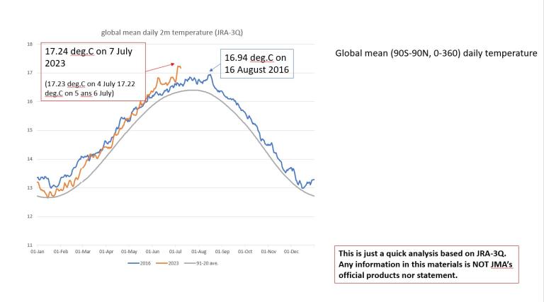
According to provisional analysis based on reanalysis data from Japan named JRA-3Q, the average global temperature on 7 July was 17.24 degrees Celsius. This is 0.3°C above the previous record of 16.94 °C on 16 August 2016 – a strong El Niño year.
The Japanese reanalysis data was made available to WMO and is not yet confirmed. But it is consistent with preliminary data from the Copernicus ECMWF ERA5 dataset.
Comparisons of daily global mean temperature are typically only available from combining observations from satellites etc with computer model simulations, into datasets called reanalyses. WMO uses a combination of reanalysis datasets with global observations from land surface stations and ships for its State of the Climate reports and to assess global temperatures.
« According to various datasets from our partners in different parts of the world, the first week of July set a new record in terms of daily temperatures,” said Dr Omar Baddour, chief of climate monitoring at WMO. “The WMO and wider scientific community are closely watching these dramatic changes in different components of the climate system, and sea surface temperatures,” he told a media briefing.

Hottest June
A report from the European Union’s Copernicus Climate Change Service – a close collaborator with the World Meteorological Organization – showed that June 2023 was just over 0.5°C above the 1991-2020 average, smashing the previous record of June 2019.
Record June temperatures were experienced across northwest Europe, according to Copernicus. Parts of Canada, the United States, Mexico, Asia, and eastern Australia were significantly warmer than normal.
June wasn't the hottest everywhere, in fact It was cooler than normal in a few places including over western Australia, the western United States, and western Russia.
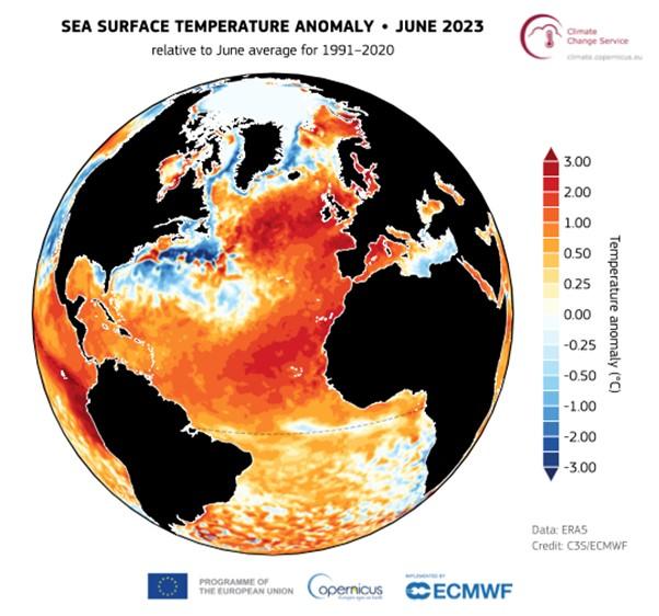
The report by the Copernicus Climate Change Service, implemented by the European Centre for Medium-Range Weather Forecasting. said North Atlantic sea surface temperatures were “off the charts.

Global sea surface temperatures were at record high for the time of the year both in May and June. This comes with a cost. It will impact fisheries distribution and the ocean circulation in general, with knock-on effects on the climate. It is not only the surface temperature, but the whole ocean is becoming warmer and absorbing energy that will remain there for hundreds of years. Alarm bells are ringing especially loudly because of the unprecedented sea surface temperatures in the North Atlantic.
"The temperatures in the North Atlantic are unprecedented and of great concern. They are much higher than anything the models predicted, » said Dr Michael Sparrow, head of WMO’s World Climate Research Department. “This will have a knock on effect on ecosystems and fisheries and on our weather, " he said.
“The North Atlantic is one of the key drivers of extreme weather. With the warming of the Atlantic there is an increasing likelihood of more hurricanes and tropical cyclones. North Atlantic sea surface temperature is associated with heavy rain or drought in West Africa,” said Dr Baddour.
Extreme marine heatwaves were observed in June around Ireland, the United Kingdom and in the Baltic Sea, according to the Copernicus Climate Change monthly report.
The heat in the North Atlantic is caused by a combination of short-term anomalous circulation in the atmosphere and longer-term changes in the ocean, according to the assessment from Copernicus Climate Change Service. It is not believed to be linked to El Niño, which is only just becoming established in the tropical Pacific and is expected to influence temperatures later in the year and into 2024.

Sea ice
Antarctic sea ice reached its lowest extent for June since satellite observations began, at 17% below average, breaking the previous June record by a substantial margin.
Throughout the month, the daily Antarctic sea ice extent remained at unprecedented low values for the time of year.
There was about 2.6 million square kilometers of Antarctic sea ice loss compared to the long-term average of the satellite era and almost 1.2 million km2 compared to the previous record in 2022.
"That is a really dramatic drop in the sea ice extent in Antarctica," said Dr Baddour.
Arctic sea ice extent was slightly below average but well above the June values from the past eight years.


Hydrological highlights
June 2023 was drier than average over much of North America, conditions which favoured and sustained severe wildfires. It was also drier in Russia, the Horn of Africa, most of Southern Africa, South America, and regions of Australia, according to Copernicus Climate Change Service.
It was wetter than average over most of Southern Europe, western Iceland and north-western Russia, with heavy precipitation leading to floods.
Drier-than-average conditions established over a large west-to-east band across Central and Eastern Europe and Scandinavia, as well as over the western coast of the Black Sea Extratropical wetter-than-average regions included western North America, regions of south-western Asia, Japan, South Africa, Brazil, Chile, New Zealand, and a large region of Australia; Japan and Pakistan were hit by typhoon Mawar and cyclone Biparjoy, respectively.


