Global Seasonal Climate Update for March-April-May 2026
Observed Oceanic Drivers for the Previous Season
From November 2025 through January 2026, global sea-surface temperatures (SSTs) remained broadly above average, with the extratropical oceans in both hemispheres exhibiting pronounced warmth1. In the equatorial Pacific, SSTs east of the Date Line stayed below average and maintained their amplitude; consequently, Niño indices remained in weak La Niña territory without significant fluctuation.
Despite these near-average anomalies in the central and eastern equatorial Pacific, enhanced east–west SST gradients sustained coupled ocean–atmosphere signals characteristic of a weak La Niña. This was most evident in the observed rainfall anomalies.
In the Indian Ocean, the Indian Ocean Dipole (IOD) index remained in a negative phase. This was primarily driven by sustained above-normal SSTs in the eastern Indian Ocean near Indonesia, though their intensity has begun to decline. Within the Atlantic basin, SST anomalies in the North Tropical Atlantic (NTA) and South Tropical Atlantic (STA) remained slightly above average, while significant warmth persisted across the extratropical North Atlantic.

Outlook for Oceanic Drivers for the Next Season
For the March–May (MAM) 2026 season, forecast for SST patterns indicate a period of transition across equatorial Pacific. Below-average SST anomalies in the central and eastern equatorial Pacific are forecast to weaken, signaling a move toward ENSO-neutral conditions as the current weak La Niña dissipates. Despite this oceanic warming, persistently above-average SSTs in the western Pacific are expected to maintain a east–west temperature gradient. This gradient is likely to continue reinforcing La Niña-like atmospheric responses.
In the Indian Ocean, the IOD index is projected to weaken from its recent negative state toward near-average conditions. Meanwhile, the Atlantic basin is expected to remain generally warm; SSTs in both the North and South Tropical Atlantic are predicted to stay slightly above normal, maintaining the broad trend of above-average Atlantic warmth observed over the preceding seasons.
Surface Temperature Outlook for the Next Season
For the MAM 2026 season, multi-model ensemble forecasts indicate a widespread global signal for above-normal land surface temperatures. High model agreement is particularly evident across much of the Northern Hemisphere mid-latitudes between 30°N and 60°N. Elevated probabilities for above-normal conditions are forecast for southern North America, Central America, and the Caribbean, supported by robust model consistency. In contrast, while Europe, northern Africa, and western north Asia show a moderate increase in the likelihood of warmer-than-normal temperatures, northwestern North America lacks a consistent signal among models.
In the Southern Hemisphere, enhanced probabilities for above-normal temperatures are projected for northern New Zealand and parts of South America. Most of Australia and southern Africa south of 10°S exhibit only a weak enhancement in the probability of above-normal temperatures. Across the tropics, strong signals for above-normal warmth are expected over equatorial Africa and the Maritime Continent, reinforced by moderate to strong agreement across multiple forecast systems.
Oceanic forecasts project widespread above-normal temperatures across the North Pacific, most of the South Pacific west of 150°W, the South Atlantic, the western North Atlantic below 30°N, and the equatorial Indian Ocean. A notable exception is a band in the North Pacific along 30°N between 120°E and the Date Line where there is weak enhancement in probabilities for near-normal temperature. In the equatorial Pacific east of the Date Line, an increased probability of near-normal temperatures indicates the coupled ocean-atmosphere system is likely to evolve toward ENSO-neutral conditions during this period.
Rainfall Outlook for the Next Season
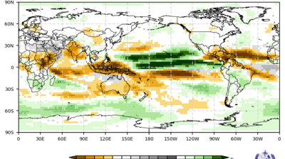
For the MAM 2026 season, rainfall predictions in the equatorial Pacific remain consistent with a lingering La Niña-like atmospheric response, even as SSTs are predicted to transition toward ENSO-neutral conditions. This feature is driven by an enhanced east–west SST gradient that continues to influence tropical convection. Just south of the equator, a broad area of enhanced probabilities for below-normal rainfall extends from 170°E to approximately 120°W, before arcing southeastward and terminating near 90°W. Similarly, the eastern side of the Maritime Continent is expected to experience a higher likelihood of below-normal rainfall. Along the equatorial strip from 160°W to the South American coast, the forecast leans toward near-normal rainfall. In the Northern Hemisphere, a corridor of above-normal rainfall probabilities originates near the Philippine Sea and stretches eastward along 15°N to 150°W.
Outside the Pacific, the equatorial Atlantic is forecast to see a moderate enhancement in probabilities for below-normal rainfall. A slight increase in the likelihood of above-normal precipitation are projected for northwestern North America, the Indian subcontinent, and northern Asia. In contrast, the rainfall signals for Africa, South America, and Europe remain relatively weak and lack strong multi-model consistency, suggesting higher uncertainty for these regions during the spring transition.
1 https://www.cpc.ncep.noaa.gov/products/attribution/images/Attribution202601.pdf


 at sunset. Source- westend61.jpg")