WMO certifies Megaflash lightning extremes
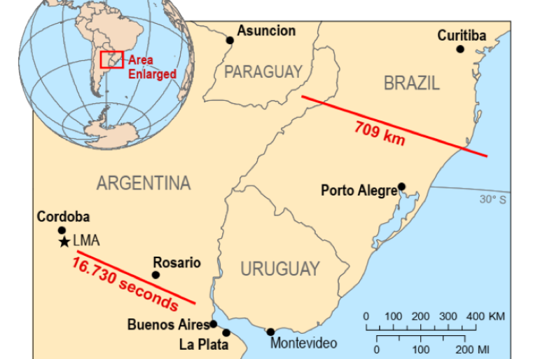
Geneva, 26 June, 2020 (WMO) A World Meteorological Organization (WMO) committee of experts has established two new world records for the longest reported distance and the longest reported duration for a single lightning flash in, respectively, Brazil and Argentina.
The new records for “megaflashes”, verified with new satellite lightning imagery technology, more than double the previous values measured in the United States of America and France. The findings were published by the American Geophysical Union’s Geophysical Research Letters ahead of International Lightning Safety Day on 28 June.
WMO’s Committee on Weather and Climate Extremes, which maintains official records of global, hemispheric and regional extremes found that:
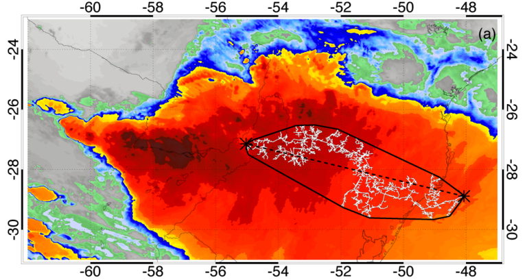
- The world’s greatest extent for a single lightning flash is a single flash that covered a horizontal distance of 709 ± 8 km (440.6 ± 5 mi) across parts of southern Brazil on 31 October 2018. This is equivalent to the distance between Boston and Washington DC in the United States of America or between London and the border of Switzerland near Basel.
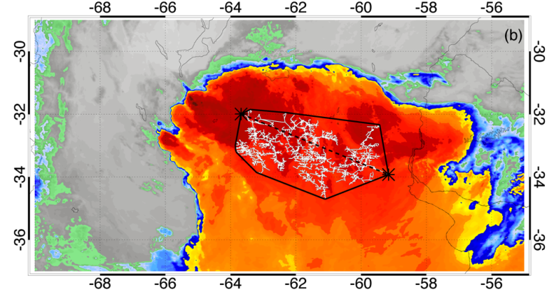
- The greatest duration for a single lightning flash is 16.73 seconds from a flash that developed continuously over northern Argentina on 4 March 2019.
|
|
| Satellite image of record extent of lightning flash, Brazil, 31 October 2018 | Satellite image of record duration of lightning flash, Argentina, 4 March 2019 |
“These are extraordinary records from single lightning flash events. Environmental extremes are living measurements of what nature is capable, as well as scientific progress in being able to make such assessments. It is likely that even greater extremes still exist, and that we will be able to observe them as lightning detection technology improves,” said Professor Randall Cerveny, chief rapporteur of Weather and Climate Extremes for WMO.
“This will provide valuable information for establishing limits to the scale of lightning – including megaflashes - for engineering, safety and scientific concerns,” he said.
Lightning is a major hazard that claims many lives every year. The findings highlight important public lightning safety concerns for electrified clouds where flashes can travel extremely large distances (30-30 rule – if time between flash and thunder is less than 30 seconds, go inside! And wait 30 minutes after the last observed flash to resume outdoor activities).
The previous record for the longest detected distance for a single lightning flash was for 321 km (199.5 miles) on 20 June 2007 across the U.S. state of Oklahoma. Both the previous and new record used the same maximum great circle distance methodology to measure flash extent.
The previous record for duration was for a single lightning flash that lasted continuously for 7.74 seconds on 30 August 2012 over Provence-Alpes-Côte d'Azur, France.
Space-based technology
The previous assessments that established the flash duration and extent records used data collected by ground-based Lightning Mapping Array networks. Many lightning scientists acknowledged that there are upper limits for the scale of lightning that could be observed by any existing LMA. Identifying megaflashes beyond these extremes would require a lightning mapping technology with a larger observation domain.
Recent advances in space-based lightning mapping offer the ability to measure flash extent and duration continuously over broad geospatial domains. These new instruments include the Geostationary Lightning Mappers (GLMs) on the R-series Geostationary Operational Environmental Satellites (GOES-16 and 17) that recorded the new lightning records, and their orbiting counterparts from Europe (the Meteosat Third Generation (MTG) Lightning Imager) and China (FY-4 Lightning Mapping Imager).
“This dramatic augmentation of our space-based remote sensing capabilities has allowed the detection of previously unobserved extremes in lightning occurrence, known as ‘megaflashes,’ which are defined as horizontal mesoscale lightning discharges that reach 100s of kilometers in length,” said lead author and evaluation committee member Michael J. Peterson, of the Space and Remote Sensing Group (ISR-2) of Los Alamos National Laboratory, USA.
The space-based instruments will provide near-global coverage of total lightning (both intracloud flashes and cloud-to-ground flashes). This includes the Americas hotspots for Mesoscale Convective System (MCS) thunderstorms whose dynamics permit extraordinary megaflashes to occur – namely, the Great Plains in North America, and the La Plata basin in South America.
The WMO Archive of Weather and Climate Extremes maintains official records of the world, hemispheric and regional extreme records associated with a number of specific types of weather. Presently, the Archive lists extremes for temperature, pressure, rainfall, hail, wind, and lightning as well as two specific types of storms, tornadoes and tropical cyclones.
Other previously accepted WMO lightning extremes are:
- Direct strike: 21 people killed by a single flash of lightning as they huddled for safety in a hut in Zimbabwe in 1975.
- Indirect strike: 469 people killed in Dronka Egypt when lightning struck a set of oil tanks, causing burning oil to flood the town in 1994.
For further information contact:
Clare Nullis, media officer. Email cnullis wmo [dot] int (cnullis[at]wmo[dot]int). Cell +41 79 709 13 97
WMO Weather and Climate Extremes Rapporteur Randall S. Cervenyemail:cerveny asu [dot] edu (cerveny[at]asu[dot]edu)
Notes to Editors
Committee Members (countries listed in parenthesis after affiliation)
Michael J. Peterson, ISR-2, Los Alamos National Laboratory, USA
Timothy J. Lang, NASA Marshall Space Flight Center, USA
Eric C. Bruning, Texas Tech University, USA
Rachel Albrecht, Universidade da São, São Paulo, Brazil
Richard J. Blakeslee, NASA Marshall Space Flight Center, USA
Walter A. Lyons, FMA Research, Fort Collins, USA
Stéphane Pédeboy, Météorage, Pau France
William Rison, New Mexico Tech, Socorro, USA
Yijun Zhang, Fudan University, Shanghai, China
Manola Brunet, University Rovira i Virgili, Tarragona Spain & University of East Anglia, Norwich UK
Randall S. Cerveny, Arizona State University, Tempe AZ USA
Notes to Editors
Geneva, 26 June, 2020 (WMO) A World Meteorological Organization (WMO) committee of experts has established two new world records for the longest reported distance and the longest reported duration for a single lightning flash in, respectively, Brazil and Argentina.
The new records for “megaflashes”, verified with new satellite lightning imagery technology, more than double the previous values measured in the United States of America and France. The findings were published by the American Geophysical Union’s Geophysical Research Letters ahead of International Lightning Safety Day on 28 June.
WMO’s Committee on Weather and Climate Extremes, which maintains official records of global, hemispheric and regional extremes found that:
- The world’s greatest extent for a single lightning flash is a single flash that covered a horizontal distance of 709 ± 8 km (440.6 ± 5 mi) across parts of southern Brazil on 31 October 2018. This is equivalent to the distance between Boston and Washington DC in the United States of America or between London and the border of Switzerland near Basel.
- The greatest duration for a single lightning flash is 16.73 seconds from a flash that developed continuously over northern Argentina on 4 March 2019.

|

|
| Satellite image of record extent of lightning flash, Brazil, 31 October 2018 | Satellite image of record duration of lightning flash, Argentina, 4 March 2019 |
“These are extraordinary records from single lightning flash events. Environmental extremes are living measurements of what nature is capable, as well as scientific progress in being able to make such assessments. It is likely that even greater extremes still exist, and that we will be able to observe them as lightning detection technology improves,” said Professor Randall Cerveny, chief rapporteur of Weather and Climate Extremes for WMO.
“This will provide valuable information for establishing limits to the scale of lightning – including megaflashes - for engineering, safety and scientific concerns,” he said.
Lightning is a major hazard that claims many lives every year. The findings highlight important public lightning safety concerns for electrified clouds where flashes can travel extremely large distances (30-30 rule – if time between flash and thunder is less than 30 seconds, go inside! And wait 30 minutes after the last observed flash to resume outdoor activities).
The previous record for the longest detected distance for a single lightning flash was for 321 km (199.5 miles) on 20 June 2007 across the U.S. state of Oklahoma. Both the previous and new record used the same maximum great circle distance methodology to measure flash extent.
The previous record for duration was for a single lightning flash that lasted continuously for 7.74 seconds on 30 August 2012 over Provence-Alpes-Côte d'Azur, France.
Space-based technology
The previous assessments that established the flash duration and extent records used data collected by ground-based Lightning Mapping Array networks. Many lightning scientists acknowledged that there are upper limits for the scale of lightning that could be observed by any existing LMA. Identifying megaflashes beyond these extremes would require a lightning mapping technology with a larger observation domain.
Recent advances in space-based lightning mapping offer the ability to measure flash extent and duration continuously over broad geospatial domains. These new instruments include the Geostationary Lightning Mappers (GLMs) on the R-series Geostationary Operational Environmental Satellites (GOES-16 and 17) that recorded the new lightning records, and their orbiting counterparts from Europe (the Meteosat Third Generation (MTG) Lightning Imager) and China (FY-4 Lightning Mapping Imager).
“This dramatic augmentation of our space-based remote sensing capabilities has allowed the detection of previously unobserved extremes in lightning occurrence, known as ‘megaflashes,’ which are defined as horizontal mesoscale lightning discharges that reach 100s of kilometers in length,” said lead author and evaluation committee member Michael J. Peterson, of the Space and Remote Sensing Group (ISR-2) of Los Alamos National Laboratory, USA.
The space-based instruments will provide near-global coverage of total lightning (both intracloud flashes and cloud-to-ground flashes). This includes the Americas hotspots for Mesoscale Convective System (MCS) thunderstorms whose dynamics permit extraordinary megaflashes to occur – namely, the Great Plains in North America, and the La Plata basin in South America.
The WMO Archive of Weather and Climate Extremes maintains official records of the world, hemispheric and regional extreme records associated with a number of specific types of weather. Presently, the Archive lists extremes for temperature, pressure, rainfall, hail, wind, and lightning as well as two specific types of storms, tornadoes and tropical cyclones.
Other previously accepted WMO lightning extremes are:
- Direct strike: 21 people killed by a single flash of lightning as they huddled for safety in a hut in Zimbabwe in 1975.
- Indirect strike: 469 people killed in Dronka Egypt when lightning struck a set of oil tanks, causing burning oil to flood the town in 1994.
Notes to Editors
Committee Members (countries listed in parenthesis after affiliation)
Michael J. Peterson, ISR-2, Los Alamos National Laboratory, USA
Timothy J. Lang, NASA Marshall Space Flight Center, USA
Eric C. Bruning, Texas Tech University, USA
Rachel Albrecht, Universidade da São, São Paulo, Brazil
Richard J. Blakeslee, NASA Marshall Space Flight Center, USA
Walter A. Lyons, FMA Research, Fort Collins, USA
Stéphane Pédeboy, Météorage, Pau France
William Rison, New Mexico Tech, Socorro, USA
Yijun Zhang, Fudan University, Shanghai, China
Manola Brunet, University Rovira i Virgili, Tarragona Spain & University of East Anglia, Norwich UK
Randall S. Cerveny, Arizona State University, Tempe AZ USA
The World Meteorological Organization is the United Nations System’s authoritative voice on Weather, Climate and Water.
For further information, please contact:
- Clare Nullis WMO media officer cnullis@wmo.int +41 79 709 13 97
- Randall S. Cerveny WMO Weather and Climate Extremes Rapporteur cerveny@asu.edu

