Another La Niña impacts temperatures and precipitation – but not climate change
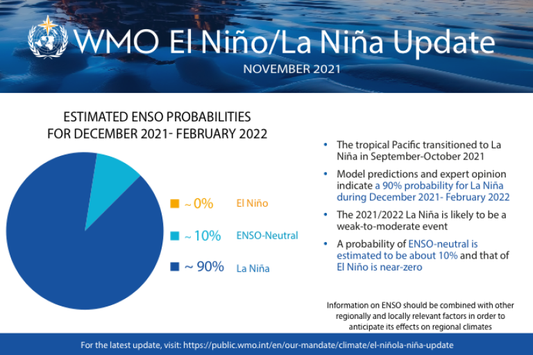
La Niña has developed for the second consecutive year and is expected to last into early 2022, influencing temperatures and precipitation. Despite the cooling influence of this naturally occurring climate phenomenon, temperatures in many parts of the world are expected to be above average because of the accumulated heat trapped in the atmosphere as a result of record high levels of greenhouse gases, according to the World Meteorological Organization (WMO).

Geneva, 30 November 2021 (WMO) - La Niña has developed for the second consecutive year and is expected to last into early 2022, influencing temperatures and precipitation. Despite the cooling influence of this naturally occurring climate phenomenon, temperatures in many parts of the world are expected to be above average because of the accumulated heat trapped in the atmosphere as a result of record high levels of greenhouse gases, according to the World Meteorological Organization (WMO).
Most models indicate that the 2021/2022 La Niña is likely to be weak to moderate – slightly weaker than the 2020/2021 event.
Even so, climate-sensitive sectors like agriculture, health, water resources and disaster management will be affected. WMO provides support and advice for international humanitarian agencies to try to reduce impacts at a time when coping capacities in vulnerable countries have been stretched by extreme weather and the continuing COVID-19 pandemic.
La Niña refers to the large-scale cooling of the ocean surface temperatures in the central and eastern equatorial Pacific Ocean, coupled with changes in the tropical atmospheric circulation, namely winds, pressure and rainfall. It usually has the opposite effects on weather and climate as El Niño, which is the warm phase of the so-called El Niño Southern Oscillation (ENSO).
“The cooling impact of the 2020/2021 La Niña – which is typically felt in the second half of the event – means that 2021 will be one of the ten warmest years on record, rather than THE warmest year. This is a short-lived respite and does not reverse the long-term warming trend or reduce the urgency of climate action,” said WMO Secretary-General Prof. Petteri Taalas.
According to the WMO Update, there is a high chance (90%) of tropical Pacific sea surface temperatures remaining at La Niña levels until the end of 2021, and a moderate chance (70-80%) for them to persist at La Niña levels through the first quarter of 2022. This is based on forecasts from WMO Global Producing Centres of Long-Range Forecasts and expert interpretation.
Global Seasonal Climate Update
The El Niño Southern Oscillation (ENSO) is the dominant driver of naturally occurring climate variability and also the main source of seasonal climate predictability. In a warmer world, the associated ENSO precipitation variability on regional scales is likely to intensify, according to the latest report from the Intergovernmental Panel on Climate Change (IPCC AR6 WG1).
El Niño and La Niña are not the only factors and no two La Niña or El Niño events are the same. WMO therefore now issues a monthly Global Seasonal Climate Update (GSCU) to provide additional actionable information to decision-makers.
In addition to El Niño and La Niña, the GSCU incorporates influences of other climate drivers, such as the North Atlantic Oscillation, the Indian Ocean Dipole, to assess their likely effects on regional surface temperature and precipitation patterns and as such used to underpin much of the seasonal discussions with the United Nations and other partners.
Therefore, decision makers should always monitor latest seasonal forecasts for the most up to date information.

Probabilistic forecasts of surface air temperature for December-February 2021-2022.
The baseline period is 1993–2009.
Figure is generated by The WMO Lead Centre for Long-Range Forecast Multi-Model Ensemble.
Despite the weak La Niña conditions in the equatorial central and eastern Pacific, the widespread warmer-than-average sea surfaces elsewhere dominate the forecast of air temperatures for December–February 2021-2022, according to the GSCU.
Many land areas are expected to see above average temperatures, with the only large exceptions being north-western North America, the Indian subcontinent, the Indochinese Peninsula, and Australia.
An unusually warm winter is forecast in the far northern and north-eastern parts of Asia and the Arctic. Above average temperatures are also expected in eastern and southeastern parts of North America, including much of the Caribbean, and over the northeastern parts of Asia and much of Europe, according to the models.
Further South, above average temperatures are predicted over a large area from the Maritime subcontinent extending into the South Pacific, as well as near equatorial Africa extending south-eastwards over Madagascar.
Near-normal or below-normal temperatures are predicted for most of South America north of about 15º S, while much of the west coast of South America is expected to see below-normal temperature.
Precipitation
Some typical rainfall impacts of La Niña are expected. There are increased chances of unusually dry conditions along the equator centred near the dateline and extending towards the southernmost part of South America and in northwestern parts of southern Asia and the Middle East.
Anomalously wet conditions are predicted in parts of Southeast Asia immediately north of the Equator and extending into the South-West Pacific and North-Central Pacific, as well as North-eastern and the far North-western part of South America.
There are weaker indications of unusually wet conditions over part of western North America and over some parts of Southern Africa, as well as much of Australia.
Over much of the rest of Africa, Europe and Asia, there is little consistency in predicted rainfall.

Probabilistic forecasts of precipitation for the season for December - February 2021-2022.
The baseline period is 1993– 2009.
Figure is generated by The WMO Lead Centre for Long-Range Forecast Multi-Model Ensemble.
The World Meteorological Organization is the United Nations System’s authoritative voice on Weather, Climate and Water

