Water and Climate: Issues, Examples and Potential in the Context of Hydrological Prediction

by Ann Calver*
Introduction
The interplay between hydrological and climatological information and analyses offers a maturing capability to assess expected terrestrial water regimes. This article is concerned with hydrological aspects of this water-climate linkage. It considers the major areas of information exchange between the two domains that enhance the capabilities of both. It then discusses capabilities of hydrological analyses in assessing impacts of climate conditions, describing some specific examples in flood and water resource contexts to illustrate both potentials and difficulties associated with such analyses. The final section of the article deals with future challenges to be met in this area of prediction in the terrestrial phase of the water cycle.
The use of hydrological analyses and modelling to explore climate impacts is by no means a new field of investigation, nor is the need for data exchange between atmospheric and Earth sciences a new requirement. It is, however, the case that there is currently a compelling impetus in these activities because of perceived improvement in technical developments in predictive tools and, in many regions of the world, increased awareness and concern of possible climate-induced changes in water regimes and availability. The considerations addressed in the article are important not only in the light of any man-induced changes to the climate system but to the management of terrestrial water under the ubiquitous conditions of natural variability of the climate system.
The question of climatic impact on the hydrological domain is an area of widespread concern, investigation and publication, both of global scale and overview information and of many academic articles addressing specific points of research. Useful examples of wide scale work, but by no means the only sources, include Bates et al. (2008); Dialogue on Water and Climate (2003); European Commission (2005); and WMO (2009).
In this article, the time base in the consideration of climate (as opposed to meteorology) is taken to be greater than seasonal, with the emphasis on periods of years and decades: it is of course the case that linkages between the atmospheric and terrestrial water domains also enhance shorter-term predictions, albeit used in a somewhat different manner. The term hydrology is used in the sense of covering the land phase of the water cycle (natural and managed): the interaction of the marine environment with the climate system is beyond the scope of this article, as are issues of water quality, as opposed to water quantity. The aim of the article is to discuss the nature and direction of some technical developments, together with their potential and drawbacks, and to look at some example applications addressing major strands, accompanying this with comment on key research aspects required to tackle the provision of appropriate information.
Information flows between climate and water domains
This section gives a succinct overview of the main aspects of information which the hydrological practitioner and researcher benefit from receiving from the climatological community, together with the information which hydrologists can usefully provide to enhance climatological science. It is interesting to note that hydrology-to-climatology data exchanges are used primarily to enhance climate modelling capability, whilst climatology-to-hydrology information flow, as well as enhancing predictive hydrology, also plays a more direct part in policy and management decision-making, reflecting the scope in the land phase of the hydrological cycle to effect hazard-reducing action.
The key aspects of water-related information which benefit climate scientists are the topographic configuration of the region of concern, including that of major water bodies, the character of soil and aquifer classes and their distributions, and land uses and management, both urban and rural. The more highly dynamic aspects are river and water body levels and soil and aquifer water contents, together with surface temperatures and state of vegetation growth. The scale of information provision needs to be made compatible with the operating resolution of global (or general atmospheric) circulation models (GCMs), commonly around 150-300 km, and with regional climate models (RCMs) at around 25-50 km. Data rescue and infilling are of importance, as well as scale transformations. Remotely sensed data are increasingly looked to in providing good spatial coverage, albeit sometimes of useful rather than ideal-choice variables.
Figure 1 shows the atmosphere/land surface interface of the United Kingdom Met Office Unified Model (MetUM) (see, for example, Cullen, 1993; Essery et al., 2003) where the linkages and feedbacks across the atmospheric/terrestrial boundary are highlighted. MetUM has been designed to allow configurations for use in weather forecasting and climate predictions: DePreSys, for example, deals with decadal predictions; PRECIS serves as a regional climate model; and HadGEM as a global climate model predicting up to a century ahead. MetUM formulations are used in a number of countries in addition to the United Kingdom, including Australia, India, the Republic of Korea, New Zealand, Norway and South Africa. It is important to note that, whilst some hydrological modelling is carried out within systems coupled to atmospheric models, arguably a greater amount is undertaken in uncoupled mode with atmospheric drivers.
 |
|
The key outputs from climate models of benefit to hydrologists are precipitation and temperature fields at a range of time and space scales. With, often, further transformation to finer scales, this information, combined with other regional and/or catchment data, facilitates statistical and/or physically based analyses of the hydrological system. The availability of past hydrological records allows methods to be tested for performance before being used in predictive mode with future climate drivers. Whilst concern is sometimes raised that conditions of the future may be outside the range of those tested in the past, to do the latter testing is a wise step if at all feasible.
Good precipitation predictions over space and time are plainly an essential requirement, as also are temperature and wind fields for determining snow and ice conditions and evaporation. For some risks, notably flooding, there is a compelling need for reliable rainfall extremes, including those at short durations: this is the case for long-term frequency quantification as well as for (near-) real-time in that short-term intensities can be of crucial hydrological importance. The rate and direction of any climatic trend are valuable indicators, even where specific numerical predictions are not possible: they are especially valuable if the cause of the trend is reliably identifiable. The scientific uncertainty around climate projections is being quantified: of value to the practitioner is an expression of the reliability of climate projections. To effect good hydrological projections, further data in addition to those of climate are plainly required, notably other environmental information and that from social and economic sciences, including adaptation possibilities. This, in turn, paves the way for exploration, not only of water quantity, considered here, but also of water quality, environmental quality and food and health issues.
Hydrological analyses of climate effects
Hydrological analysis encompasses many types of approaches, occasioned by a domain rich in processes and in spatial and temporal variability, by the range of levels of available data, and by the variety of requirements driving the analysis. The hydrological domain is a highly multivariate system in which it is difficult to unravel the separate effects of climate and other factors that affect the terrestrial water regime. While atmospheric and land surface processes are, to varying degrees, coupled in global and regional climate modelling, the detail of hydrological regimes is frequently as well, and in many cases better, served by essentially hydrological models, driven by time series of climatic inputs, particularly precipitation and temperature. The latter models have in many cases developed a maturity which can be capitalized on in terms, for example, of formulations for subregional structural detail of catchments, lateral water transfers and rapidly responding flood generation with accompanying representation of inundation levels. In short, to explore aspects of hydrological response to climate drivers, there are numerous methodologies which are not necessarily intimately coupled with climate model systems: a large array of generic models is available, some models encapsulated in software packages, and with a variety of code access levels. Methods range from simple parameter-sparse formulations to fully coupled surface and groundwater systems of partial differential equations solved by numerical schemes and offering three-dimensional spatial variability. Whilst the more detailed formulations plainly offer more hydrological variables and more spatial definition, it is to be noted that complex representations are not always the most appropriate, particularly when data are sparse. Statistical analyses of hydrological data complement these modelling approaches. Hydrological futures are frequently evaluated through the consideration of expected frequency distributions relating to particular periods as well as of transient time series.
With much work undertaken in exploring effects of climate variability and change on aspects of the hydrological environment, it is not a straightforward matter to choose which specific examples to discuss. Whilst recognizing opinions may differ on the most apposite, a selection of work is commented upon below, dealing with water deficit and water excess, which serves to demonstrate points of interest and relevance beyond the individual application in terms of generic capabilities and shortcomings.
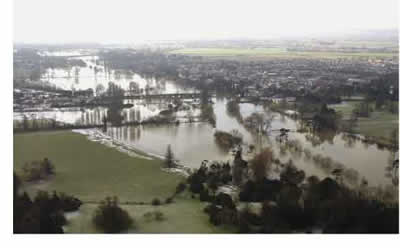
Broad-scale flood risk
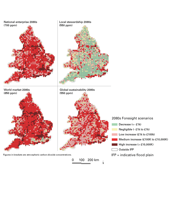
An investigation into flood risk in the United Kingdom was undertaken in 2002-2004 by a range of scientists working with the Government’s (then) Department of Trade and Industry’s “Foresight” team looking in particular at likely conditions under the climate predictions for the 2030-2100 period in order to inform policy-making. The cross-government socio-economic “futures scenarios” (Department of Trade and Industry, 2002), shown in Figure 2, were taken to represent an encapsulated range of development possibilities. These have a fair degree of generic applicability in wider regions (though the “conventional development” is arguably less transferable), covering level of governance and range of social aspirations/values.
 |
Figure 2 — Socio-economic futures scenarios, with system of governance represented on the vertical axis and social values indicated on the horizontal axis. (figure reproduced with permission, from UK Floods Foresight report (Evans et al., 2004)). |
Each of these socio-economic scenarios was linked with a likely climate scenario (Hulme et al., 2002) in terms of global greenhouse-gas emission scenarios considered compatible with the development characteristics. The estimated scale of effects of the climate drivers, together with the other influences on flood risk implicit in the development scenarios (such as environmental regulation, sea-level change, urbanization, infrastructure development, etc.) were assessed by groups of experts. The results were then factored in to a modified version (Hall et al., 2003) of an existing software system for determining, by quantitative but broad-brush hydrological and hydraulic procedures, the expected spatial extents of fluvial (1-in-100-year event) and coastal (1-in-200-year event) flooding, together with the associated cost implications in social and infrastructure terms. Extensive details of the methods are to be found in Evans et al. (2004). Figure 3 shows some results from this procedure in terms of average annual flood damage for the 2080s under the four combined climate-and-socioeconomic scenarios. Further numerical explorations introduced mitigating measures to gauge the effect of actions to reduce flood risk.
This Floods Foresight project was undoubtedly influential in the UK in raising the profile of the possible scale of climate impacts and has attracted interest in, for example, China, India, Japan, the Netherlands and the USA. It is plainly a ‘broad-brush’ approach with advantages and drawbacks inherent in such a procedure. The drawbacks centre on the inevitable need for approximation which should be recognized by the scientists but the degree to which it is apparent in outcome summaries is debatable. Some such points include the establishment of rankings and multipliers by expert groups (which, while probably the best approach one can take, may not give repeatable results); the use of global climate projections with local development scenarios; and in estimating the major rather than all sources of flooding. The advantages reside in developing good estimates across a wide spread of disciplines, including climatology and hydrology, to explore future flood risk and management options.
 |
|
Modelling uncertainties in flood probabilities
As a contrast to the above type of broad-scale approach to flood risk under changed climate, the next example considered here is a detailed modelling approach to fluvial flood risk, attempting, in particular, to quantify the errors associated with the aspects of the assessment. When using climate model predicted precipitation as input to hydrological modelling systems to predict river discharge regimes, uncertainty enters results from a range of sources. These can include the structure of the GCM used, emission scenarios, RCM structure, downscaling of climate outputs to drive runoff models and the structure of the hydrological models. Figure 4 gives an example of the relative importance of these sources of uncertainty for an investigation reported by Kay et al. (2009). The underlying form of the figure is based on a flood frequency curve, here relating change in flood peak river flow magnitude to its mean return period. The change relates to 2071-2100 projected flows in comparison with the baseline (1985-2001) observed records caused by a range of factors.
Five GCMs were used (HadCM3, CSIRO-Mk2, CGCM2, ECHAM4 and CCSR), together with eight RCMs and two hydrological catchment models, a parameter-sparse conceptual model and a grid-based runoff and routing model, the precise combinations of models being detailed in Kay et al. (op. cit.). The figure is for one particular river catchment in the United Kingdom: results are similarly available for a number of other United Kingdom catchments, the pattern of outcomes differing between them. An important background metric to be aware of is how much variation in the flood frequency curve is to be expected from “natural” climate variability without any anthropogenic climate pressures considered. The “current” variability is approximated in this work by repeated monthly resampling of the baseline data: whether this is a true reflection of the extent of variability in climate other than as a result of emissions is open to question.
A conclusion suggested in the work is that uncertainty from GCMs is the largest of the sources of uncertainty tested. The outlier GCM result (see Figure 4) is the CCSR model which is relatively extreme in terms of the winter rainfall it predicts for the United Kingdom. Limitations of even a very detailed investigation are discussed in the work.
The approach of this example, of using downscaled RCM data to drive hydrological catchment models to derive flow time series from which future flood metrics can be established, is one which the United Kingdom government has taken as the basis for its guidance on appropriate allowances to make on flood management scheme design in the light of climate variability (Department for Environment, Food and Rural Affairs, 2006; Department of Communities and Local Government, 2006). Advice has been updated as climate scenarios evolve and as model systems develop.
The work of Figure 4 is part of a suite of research seeking to offer a measure of confidence around best estimates of flood impacts from climate drivers. In a manner somewhat similar to the presentation of GCM results in terms of convergence of sign of change between different model outcomes, Bell et al. (2009), for example, have investigated whether or not different flood magnitude-frequency outcomes under different climate projections for regions of the United Kingdom show convergence in terms of the sign of the direction of change of peak flood flow at a range of recurrence intervals. This represents a welcome move towards defining the robustness of hydrological projections and is a move towards indicating probabilistic outcomes from (partial) ensembles. In even a relatively small country like the United Kingdom, and one which is relatively data-rich, the pattern, even of direction of change in (say) the 50-year recurrence interval flood is seen to be complex and accompanied by considerable error margins. These approaches are at an interesting exploratory stage of research rather than one as yet mature in practical application. Assessment of relatively comprehensive approaches like this to climate-induced hydrological impact highlight the wide array of components that can be taken into account, the variability thereby produced and the informed judgement which needs to be brought to bear in using such information in flood risk policy-making and management.
 |
Figure 4 — Sources of uncertainty, denoted by different colours, in river flood magnitude/frequency relationships from a variety of sources. Change refers to the difference between the 1985-2001 baseline and 2071-2100; results are shown for the 86 km2 River Duddon catchment in north-west England (median annual flood 120 m3/s). The “current natural variability” plots indicate the median and 90 per cent upper and lower bounds (obtained from resampling) (after Kay et al., 2009) |
|
|
|
Water demand and resource
 |
|
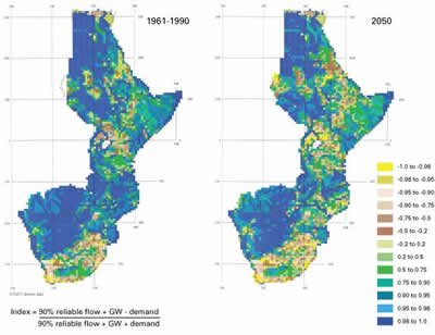
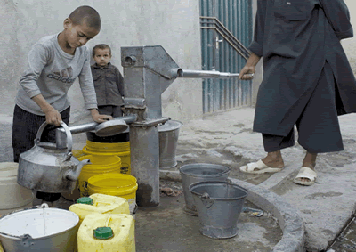
The last example in this section moves from consideration of climate effects on flooding to an investigation of impacts on water resources, again discussing an example investigation in the light of more general lessons that can be drawn on advantages and disadvantages of particular techniques. Figure 5 shows an analysis of water availability under a scenario of climate and demand change in eastern and southern Africa, covering a region of some 12.8 million km2 with a population of over 300 million. A consistent and realistic approach applied across 20 countries was sought to cover spatial and temporal variations in water availability and demands, with an impetus from the UN Environment Programme and Food and Agriculture Organization objectives.
The essence of the methodology (Meigh et al., 1999) is the estimation of surface water flows, groundwater yield and water demand on a 0.5 by 0.5 degree latitude and longitude gridded basis, using interlinked numerical estimates and conceptual models, whose parameters are derived from data with wide-scale availability such as land cover, soil type, aquifer type, population and livestock distributions. Some data infilling and some sub-model systems were incorporated: hydrological model components were tested against 1961-1990 data. Monthly climate projections to 2050 (Hulme, 1996) and water demand scenarios were considered for urban and rural populations and for agricultural and industrial developments. Details of results are given in Meigh et al. (op. cit.): in short, increased populations and the trend towards improved living standards suggested the likelihood of significant increases in the proportions of countries affected by water scarcity with, in this example, Sudan, Eritrea and Mozambique being particularly at risk from changes in water availability and parts of South Africa and regions round Lake Victoria predicted to see exacerbation of existing problems.
This semi-distributed water resource modelling system with subsequent enhancements has been used in West Africa, the Caspian Sea Basin, the Ganges-Brahmaputra Himalayan region and the South American continent. Merits of this type of approach lie in its design for spatially distributed application in the light of very data-sparse conditions and in the use of effective surrogate variables to address the issue. As such, methods like this may be considered to be more appropriately used for exploring trends and planning at regional scales rather than for estimating the specifics of local demands.
The concluding section of this article outlines challenges yet to be met beyond the undoubted insights and information that investigations like those examples described in this section have already afforded the hydrological and wider communities.
Challenges to be met
It was noted in the introduction to this article that effective planning and management of the hydrological domain is imperative whether climate is naturally and/or anthropogenically varying. Much recent research has focused on possible future changes in temperature and precipitation under anthropogenic modification of climate but, in many regions of the world, the current climate poses significant water-management problems in terms of deficit and/or excess water, particularly where natural variability is great. It has been argued that, in many regions, issues essentially of climatic variability may dominate over those of climate change for some considerable period. In terms of anthropogenic climate change, it is important to note that, in around one-third of the world (Bates et al., 2008) the expected direction of rainfall change 2090-2099 compared with that of 1980-1990 is, under the SRES A1B emission scenario (representing rapid economic growth, regional convergence and balanced energy sources), indeterminate from multi-GCM projections.
Against this background, the final part of this article looks briefly at research challenges for the way ahead. It would be advantageous to quantify natural variability in climate, the baseline against which human-induced effects operate. In general it would be good to know where greatest sensitivity in predictions arises. It is useful also to quantify, as much work increasingly does, uncertainties attributable to various sources in projections of climate and hydrological futures. Importantly, it would be good, though undoubtedly challenging, to distinguish, in the notably multivariate hydrological response, the separate effects on water regimes of factors beyond that of climate, especially of land use and surface water and groundwater management practices and regimes, not least because many adaptation measures are most readily achieved through these routes.
In order to effect some of the above aspirations, methods of transferring climate and hydrological information between temporal and spatial scales, whilst active subjects of research in terms of both statistical and physically based procedures (see, for example, Fowler et al., 2007), remain an area with scope for improvement to capture effects of physical processes, both atmospheric and terrestrial. The point has been made however that, for example, even good downscaling from a large-scale model that is itself imprecise and/or inaccurate will yield finer-discretization data which are of doubtful quality and relevance. There remains a compelling need, particularly for flood risk quantification, for more reliable estimation of extreme precipitation, particularly at fine time discretization.
|
Climate model outputs to hydrology, and indeed hydrology outputs to users, are increasingly supplied as ensembles and should be accompanied by some measure of reliability. Research can also be usefully directed to a greater degree towards spatial coherence in estimates of changes in the water regime, as opposed to arrays of (largely independent) point (or grid) estimates plotted in a spatial sense. This is of value in addressing adaptation measures and, as with other research aspects, should cover procedures for areas of low, as well as higher, data availability.
|
 |
Reference was made above to the multivariate nature of the hydrological system: it would be of value to include in hydrological methods and models an appropriately dynamic representation of the domain in terms of features (beyond water contents and flows) that can respond to changes in climate including land use, water management practices and features of socio-economic and infrastructure development. This incorporation of degrees of feedback to changing climates paves the way for the more realistic assessment of adaptation options. Readily comprehensible expressions of risk should accompany these transient hydrological scenario explorations.
From a water policy and management perspective climatological and hydrological futures are best accompanied by reliability estimates and/or guidance for management in the light of uncertainties. It may also be profitable to approach the problem by considering what water policies and actions can, given economic and political conditions, most readily be introduced to address current requirements whilst future-proofing water management. Wilby (2008) for example promotes “low-regret” solutions keeping open future adaptation options. Climate and derived hydrological scenarios can serve as test cases for checking proposed interventions rather than featuring primarily in the derivation of responses.
These types of research and actions plainly benefit from collaborative effort and information-sharing across scientific and national communities. Elucidating the separate and varied influences on the behaviour of the water cycle, while challenging, offers much potential for assessing the relative risks in hydrological changes and their patterns over space and time, together with opportunity for exploration of adaptation options for safe water regimes under evolving climatic conditions.
References
Bates, B.C., Z.W. Kundzewicz, S. Wu, and J.P. Palutikof (eds), 2008: Climate change and water. Technical paper of the Intergovernmental Panel on Climate Change, IPCC Secretariat, Geneva, 210 pp.
Bell, V.A., A.L. Kay, R.G. Jones, R.J. Moore, and N.S. Reynard, 2009: Use of soil data in a grid-based hydrological model to estimate spatial variation in changing flood risk across the UK. Journal of Hydrology (in press).
Cullen, M.J.P., 1993: The Unified Forecast/Climate Model. Meteorological Magazine, 122, 81-94.
Department of Communities and Local Government, 2006: Planning Policy Statement 25: Development and Flood Risk. Stationery Office, London.
Department for Environment, Food and Rural Affairs, 2006: Flood and Coastal Defence Appraisal Guidance FCDPAG3 Economic Appraisal. Supplementary Note to Operating Authorities: Climate Change Impacts. London, 9 pp.
Department of Trade and Industry, 2002: Foresight futures 2020: revised scenarios and guidance. HMSO, London, 32 pp.
Dialogue on Water and Climate, 2003: Climate changes the water rules: how water managers can cope with today’s climate variability and tomorrow’s climate change. Ed B. Appleton. Dialogue on Water and Climate, Netherlands, 105 pp.
Essery, R.L.H., M.J. Best, R.A. Betts, P.M. Cox and C.M. Taylor, 2003: Explicit representation of subgrid heterogeneity in a GCM land surface scheme. Journal of Hydrometeorology, 4, 530-543.
European Commission Joint Research Centre, 2005: Climate change and the European water dimension: a report to the European Water Directors. (S.J. Eisenreich (ed.), EU Report No. 21553, 253 pp.
Evans, E., R. Ashley, J. Hall, E. Penning-Rowsell, A. Saul, P. Sayers, C. Thorne and A. Watkinson, 2004: Foresight: Future flooding. Scientific summary, Volume I: Future risks and their drivers, 366 pp; Volume II: Managing future risks. Office of Science and Technology, London, 417 pp .
Fowler, H.J., S. Blenkinsop and C. Tebaldi, 2007: Linking climate change modelling to impacts studies: recent advances in downscaling techniques for hydrological modelling. International Journal of Climatology, 27, 1547-1578.
Hall, J.W., R.J. Dawson, P.B. Sayers, C. Rosu, J.B. Chatterton, and R.A. Deakin, 2003: Methodology for national-scale flood risk assessment. Proceedings of the Institution of Civil Engineers: Water, Maritime and Energy, 156, 235-247.
Hulme, M. (Ed.), 1996: Climate change and southern Africa: an exploration of some potential impacts and implications in the SADC region. Climatic Research Unit, University of East Anglia, Norwich, United Kingdom.
Hulme, M., G.J. Jenkins, X. Lu, J.R. Turnpenny, T.D. Mitchell, R.G. Jones, J. Lowe, J.M. Murphy, D. Hassell, P. Boorman, R. McDonald and S. Hill, 2002: Climate change scenarios of the United Kingdom: the UKCIP02 Scientific report. Tyndall Centre for Climate Change Research, University of East Anglia, Norwich, United Kingdom, 120 pp.
Kay, A.L., H.N. Davies, V.A. Bell and R.G. Jones, 2009: Comparison of uncertainty sources for climate change impacts: flood frequency in England. Climatic Change, 92, 41-64.
Meigh, J.R. , A.A. McKenzie, B.N. Austin, R.B. Bradford and N.S. Reynard, 1998: Assessment of global water resources—Phase II: estimates of present and future water availability for eastern and southern Africa. Institute of Hydrology report to Department for International Development, Wallingford, 55 pp.
Meigh, J.R., A.A. McKenzie and K.J. Sene, 1999: A grid-based approach to water scarcity estimates for eastern and southern Africa. Water Resources Management, 13, 85-115.
Wilby, R.L., 2008 Dealing with uncertainties of future climate: the special challenge of semi-arid regions. Proceedings of the Water Tribune: Climate change and water extremes. Expo Zaragoza, Spain.
WMO, 2009 (in preparation): Challenges and opportunities in research to enable improved products and new services in weather, climate and environment. Report of the Executive Council Task Team on research aspects of enhanced climate, weather, water and environmental prediction framework.
__________
* Centre for Ecology and Hydrology, Wallingford, Oxon, United Kingdom