Global Seasonal Climate Update for July-August-September 2024
During March-May 2024, the Pacific Niño sea-surface temperature (SST) index in the eastern Pacific (Niño 1+2) fell below-normal. Of the other three Niño indices only the Niño 4, the westernmost index, stayed above normal. The observed SST conditions in the equatorial Pacific returned to the ENSO-neutral conditions. The observed Indian Ocean Dipole (IOD) was positive but was near-normal. Both the North Tropical Atlantic (NTA) and South Tropical Atlantic (STA) SST indices were much above-normal and reflected widespread warmth in the tropical Atlantic. In general, the observed SST anomalies in global oceans were positive1.

Above-normal sea-surface temperature anomalies in the Niño 3.4 and Niño 3 regions are predicted to decline during July-September 2024 but remain in ENSO-neutral conditions, and cool further to La Niña conditions by late 2024. The strength of the Indian Ocean Dipole (IOD) index is predicted to stay near-normal. In the equatorial Atlantic, SSTs are predicted to be above-normal in both the northern (NTA) and the southern (STA) areas during the season.
.png")
.png")
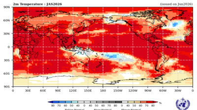
Consistent with the anticipated continuation of widespread above-normal sea-surface temperatures in almost all areas outside of the near-equatorial eastern Pacific Ocean, there is widespread prediction of above-normal temperatures over land areas. Exceptions to this widespread warmth are South America south of about 30º S and the extreme northwestern coast of North America in the vicinity of the Bering Sea. Extensive areas of large increases in probabilities for above-normal temperatures include almost all of Africa, and within about 60º N of the equator over Europe and Asia, east of 120º W over North America, Central America and the Caribbean, and above 30º S over South America. Australia, New Zealand, and most of the islands in the South Pacific have moderate to strongly increased probabilities for above-normal temperatures. North of about 60º N, North America, Europe and Asia have weak to moderately increased probabilities for above-normal temperature. South America south of about 30º S is the only extensive land area with no increase in the probability of above-normal temperature – there is no clear signal in this area. However, in coastal areas of southern South America and extending north along the west coast to just north of the equator and into the eastern Pacific below-normal temperatures are expected, consistent with the predicted emergence of La Niña conditions.
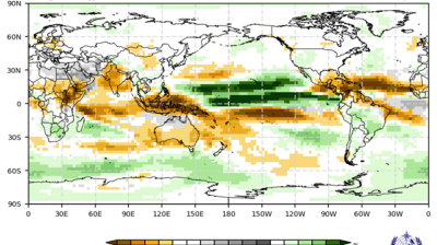
Predictions for rainfall are, in part, consistent with the canonical impacts of the early stages of La Niña conditions, which are expected to emerge later in the year. Below-normal rainfall is predicted over a narrow band along or just north of the equator from 150º E extending eastward to the southern region of Central America. There are additional bands of predicted dry conditions spanning the width of the Pacific at about 20º latitude in both Hemispheres. The Northern Hemisphere band extends into north-western Central America and the south-western part of North America. The Southern Hemisphere band is more extensive, expanding over almost the entire South America south of the equator and then across the South Atlantic. Another dry area in the southern Atlantic crosses the southernmost part of Africa and covers Madagascar, terminating at about 60º E, but reappearing over the southwestern and southern parts of the Maritime continent. There are areas of predicted increased probabilities of below-normal rainfall over parts of Europe. Much of central and eastern Africa have increased probabilities for above-normal rainfall. This wet area expands over much of the Middle East and northern Indian Ocean and parts of South Asia. It also extends along the equator through the Maritime continent and then in a narrow band immediately south of the equator as far as the central Pacific. There are strong indications of above-normal rainfall in an area centred over the Caribbean extending westward into a small area of the eastern Pacific, and eastward to the southwest coast of Africa. Weakly enhanced probabilities for above-normal rainfall are also indicated over parts of East Asia, the east coast of North America, and Greenland, as well as over much of the Southern Ocean. However, most of northern Asia, North America, North and West Africa, Australia and New Zealand have no clear signal. Areas in Africa where normal rainfall is indicated as the most likely outcome are generally arid at this time of year.
For more information: Global Seasonal Climate Update Archive.


 at sunset. Source- westend61.jpg")