El Niño is forecast to swing to La Niña later this year
The 2023/24 El Niño event, which helped fuel a spike in global temperatures and extreme weather around the world, is now showing signs of ending. There is likely to be a swing back to La Niña conditions later this year, according to a new Update from the World Meteorological Organization (WMO).
- The 2023/24 El Niño event is now showing signs of ending.
- WMO Update predicts at least 60% chance of La Niña during July-September
- Average global sea surface temperatures remain exceptionally high
- Seasonal forecasts inform early warnings and support early action

Latest forecasts from WMO Global Producing Centres of Long-Range Forecasts give equal chances (50%) of either neutral conditions or a transition to La Niña during June-August 2024. The chance of La Niña conditions increases to 60% during July-September and 70% during August-November. The chance of El Niño redeveloping is negligible during this time.
La Niña refers to the large-scale cooling of the ocean surface temperatures in the central and eastern equatorial Pacific Ocean, coupled with changes in the tropical atmospheric circulation, namely winds, pressure and rainfall. The effects of each La Niña event vary depending on the intensity, duration, time of year when it develops, and the interaction with other modes of climate variability. In many locations, especially in the tropics, La Niña produces the opposite climate impacts to El Niño.
However, naturally occurring climate events such as the El Niño Southern Oscillation (ENSO) now take place in the context of human-induced climate change, which is increasing global temperatures, exacerbating extreme weather and climate, and impacting seasonal rainfall and temperature patterns.
“Every month since June 2023 has set a new temperature record – and 2023 was by far the warmest year on record. The end of El Niño does not mean a pause, in long-term climate change as our planet will continue to warm due to heat-trapping greenhouse gases. Exceptionally high sea surface temperatures will continue to play an important role during next months," says WMO Deputy Secretary-General Ko Barrett.
The past nine years have been the warmest on record even with the cooling influence of a multi-year La Niña from 2020 to early 2023. El Niño peaked in December 2023 as one of the five strongest on record.
“Our weather will continue to be more extreme because of the extra heat and moisture in our atmosphere. This is why the Early Warnings for All initiative remains WMO’s top priority. Seasonal forecasts for El Niño and La Niña and the anticipated impacts on the climate patterns globally are an important tool to inform early warnings and early action,” said Ko Barrett, who is leading a WMO delegation at the UN Climate Change session in Bonn.
"La Niña conditions generally follow strong El Niño events, and this is in line with recent model predictions, although high uncertainty remains regarding its strength or duration" Seasonal forecast models at this time of year are known to have relatively low skills, commonly known as the Northern Hemisphere "spring predictability barrier."
Global Seasonal Climate Update


Given that ENSO is not the only driver of the Earth’s climate system, WMO also issues regular Global Seasonal Climate Updates (GSCU), which incorporate influences of the other major climate variability modes such as the North Atlantic Oscillation, the Arctic Oscillation and the Indian Ocean Dipole.
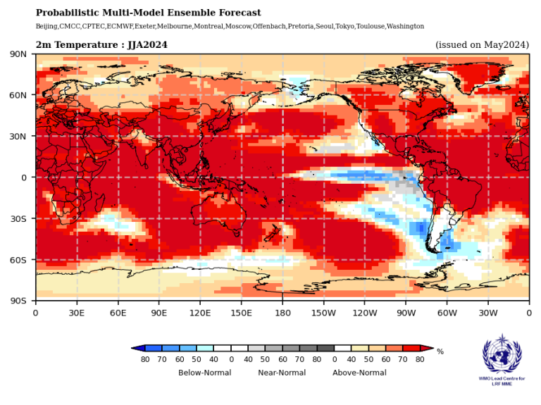
The latest GSCU says that widespread above-normal sea-surface temperatures in all areas are expected to persist outside the near-equatorial eastern Pacific Ocean. There is therefore widespread prediction of above-normal temperatures over almost all land areas.
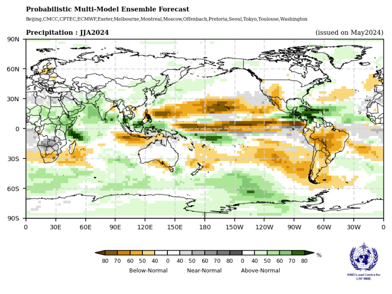
Predictions for rainfall are, in part, consistent with the typical impacts of the early stage of La Niña conditions, including above-normal rainfall in far northern South America, Central America, the Caribbean, northern Greater Horn of Africa and the Sahel, parts of southwest Asia and central Maritime Continent"
The WMO Updates are based on WMO Global Producing Centres of Long-Range Forecasts and are available to support governments, the United Nations, decision-makers and stakeholders in climate-sensitive sectors to mobilize preparations and protect lives and livelihoods.
WMO Regional Climate Centres and National Meteorological and Hydrological Services (NMHSs) will closely monitor changes in the state of ENSO over the coming months.
The World Meteorological Organization is the United Nations System’s authoritative voice on Weather, Climate and Water.
For further information, please contact:
- Clare Nullis WMO media officer cnullis@wmo.int +41 79 709 13 97
- Global Communication and Engagement Media Contact media@wmo.int

