

The Digital Transformation of Marine Meteorological and Ice Information Services
- Author(s):
- Geoff Dunsworth (ECCC/MSC), Daniel Peixoto de Carvalho (WMO)
At sea, knowing that a storm is approaching is only half the battle. Mariners also need to know where it is, how it might affect their route and how quickly they must respond. Yet critical weather warnings still often arrive as text, requiring crews to interpret coordinates and locate dangerous areas on navigational charts.
A new generation of digital services aims to change that. Developed through international collaboration involving the World Meteorological Organization (WMO), the S-41X product family will bring weather warnings, forecasts and ice information directly onto electronic navigational charts. Built on the S-100 Universal Hydrographic Data Model, these services could make it easier for mariners to identify hazards and make decisions at sea.
The current text-based approach
For decades, maritime safety information has been delivered primarily through text-based services such as NAVTEX, satellite broadcasts, and radio communications. These systems remain essential to maritime safety and will continue to play an important role.
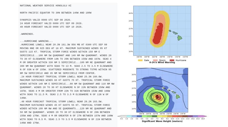
However, the way information is received places considerable responsibility on the mariner. A weather warning on board may arrive as a text-only message describing a hazardous area through a sequence of geographical coordinates. The navigating officer must read the message, interpret the coordinates and manually plot them onto a paper chart or separate digital display to determine whether the ship’s planned route enters the affected area.
Imagine doing this on the bridge of a vessel as weather conditions deteriorate and several other operational decisions demand attention. The information may be accurate and timely, but turning it into an immediate picture of the risk is time-consuming and prone to human error, particularly under such conditions.
As global shipping traffic intensifies and maritime operations become increasingly complex, the transition to fully digital, machine-readable services is not merely a technological upgrade but a critical necessity. This is where S-41X comes in.
It ensures that crucial meteorological intelligence is seamlessly integrated into the ship's primary navigation console, eliminating manual intervention and significantly reducing the cognitive load on the bridge crew.
The future is digital
The S-41X product series will transform how marine meteorological and ice information is presented to mariners. Rather than receiving this information separately from the navigational chart, relevant weather and ice data can be displayed as overlays on electronic navigational charts (ENCs) within the Electronic Chart Display and Information System (ECDIS).
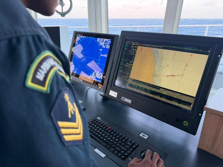
For example, a marine weather warning could appear directly as a defined area on the ship’s navigational display, allowing the mariner to immediately see its location in relation to the vessel and its planned route. Similarly, ice boundaries and concentrations could be displayed on the same navigational chart, while forecast information on wind, waves, and other conditions could provide additional context for voyage planning and decision-making.
Bringing this information into the ship’s navigational equipment can support safer navigation and more efficient routing, with potential benefits for fuel consumption, voyage time, and environmental impact. S-41X information can also be combined with other S-100 products, including those providing data on ocean currents and water levels, to help mariners make informed decisions. The technology behind these services is complex, but the principle for the mariner is simple: less time translating information, and more time understanding what it means for the voyage.
A safer way to navigate the Arctic
Diminishing sea ice is making some Arctic waters accessible for longer periods and creating opportunities for new or expanded shipping routes. But less ice does not necessarily mean safer navigation. Vessels face highly unpredictable and rapidly shifting ice fields. A ship's ECDIS that displays dynamic ice information, such as the position of icebergs, sea-ice formation, and ice concentration boundaries, allows the crew to instantly visualize safe passages rather than estimating conditions from text bulletins.
The same principle applies to rapidly intensifying storms. A traditional warning may provide the coordinates defining the warning area together with information on expected winds and other hazards. Digital warning polygons, however, can display the danger zone immediately on the navigational chart, helping the crew identify hazardous conditions and adjust their route accordingly.
The S-41X product family
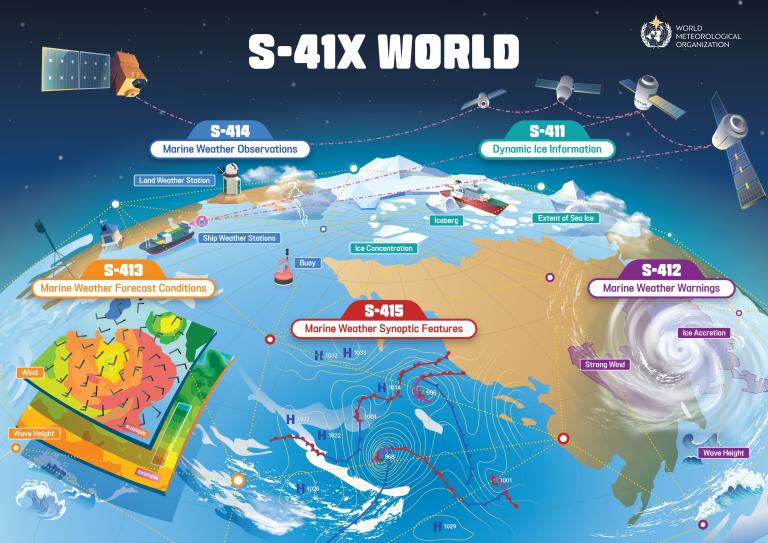
The five S-41X products cover dynamic ice information (S-411), marine weather warnings (S-412), forecast conditions (S-413), observations (S-414), and synoptic features (S-415). S-411 provides visual representations of local ice analyses and forecasts, including ice concentration, the extent of sea and lake ice, and the locations and concentrations of icebergs. Marine weather warnings in S-412 use polygons to identify areas where wind, wave, and ice accretion reach specified risk thresholds.
S-413 provides meteorological and oceanographic analyses and forecasts in gridded numerical formats, complementing the warnings provided by S-412. S-414 provides observations from a range of in-situ and remote sensing sources. Finally, S-415 provides maps of current and forecast weather patterns over the oceans, including, tropical cyclones and other disturbances, and areas of low and high atmospheric pressure.
The technical challenges
Turning S-41X into operational services will require overcoming several hurdles. Implementation is expected to take place in phases, with S-411 and S-412 targeted to become operational in 2029, followed by the remaining products. One of the main challenges is the high frequency of updates required for dynamic weather and ice data. Unlike standard navigational charts and seabed maps, which change slowly over months or years, S-41X products require updates in near real time, ranging from every 30 minutes to a few hours.
Another challenge is presenting complex, dynamic data without overwhelming the mariner. While a traditional weather forecast map might display multiple overlapping weather systems, wind patterns and wave conditions, an ECDIS screen is first and foremost a navigational tool where clarity is paramount. Weather and ice information must be presented without obscuring essential information such as shallow water, reefs, navigation routes, shipping lane boundaries or other hazards.
Developers are therefore testing different ways to display weather and ice information without obscuring the underlying chart. These include transparent warning areas, different line patterns and symbols that help mariners distinguish between hazards and assess their severity at a glance. Feedback from mariners and technical experts will help establish consistent approaches to symbols, warning boundaries, transparency and other graphical elements.
Developers also face hurdles related to interoperability between different digital systems, the development of specialized software for data production and validation, the future establishment of business models, and cybersecurity challenges associated with data distribution.
Another obstacle is the availability of compatible navigation equipment. S-100 compatible ECDIS equipment remains in the testing phase, delaying the immediate deployment of S-41X products. Finally, national services will need systems capable of producing, quality-controlling and distributing these digital datasets while, during the transition, continuing to provide existing maritime safety information services.
Towards S-41X implementation
Recognizing these technical hurdles, including the need for Members to issue and broadcast text-based and S-41X products simultaneously, the World Meteorological Organization (WMO) is preparing to support National Meteorological and Hydrological Services (NMHSs), Marine Meteorological Services (MMSs), and Ice Services. The WMO Commission for Weather, Climate, Hydrological, Marine, and Related Environmental Services and Applications (SERCOM) is supporting preparations for S-41X implementation through the development of documentation and proposed resolutions. An S-41X side event during its fourth session (SERCOM-4) raised awareness and fostered international collaboration.
WMO already provides guidance and resources through a dedicated S-41X web portal which offers national services information on preparing datasets, managing quality control and testing operational environments.
The transition will take time. WMO will continue to support international collaboration as the different product specifications are introduced. WMO encourages national services to evaluate their software solutions and coordinate closely with their respective national hydrographic offices to leverage existing expertise in S-100 production tools. A comprehensive S-41X Handbook is also under development to guide Members through the transition.
S-41X offers the possibility of bringing authoritative weather and ice information directly into the digital environment in which modern navigation decisions are made. The familiar text warning will not disappear overnight, nor should technology replace professional judgement on the bridge. But a warning that once had to be read, interpreted and manually plotted on a chart could soon appear directly on the navigation screen, giving mariners a clearer picture of the hazards ahead.