Sea-surface temperatures reflect strengthening El Niño

Geneva, Switzerland (WMO) - Sea-surface temperatures in the central and eastern tropical Pacific are forecast to increase to record levels during October-November-December 2026, reflecting the strengthening of the El Niño event which will drive weather patterns and impact economies, ecosystems and communities across the globe.
The monthly Global Seasonal Climate Update from the World Meteorological Organization (WMO) says that El Niño will continue to intensify ahead of its forecast peak in December. It is likely to bring above-average temperatures to much of the globe and shift rainfall patterns, increasing the risk of drought and floods in different regions.
The Global Seasonal Climate Update provides authoritative information about large-scale climate drivers. These include the El Niño–Southern Oscillation (ENSO), the Indian Ocean Dipole (IOD) and tropical Atlantic sea-surface temperatures which all impact seasonal temperature and rainfall. It complements WMO’s El Niño/La Niña Update, which is issued quarterly.
“El Niño is firmly established and strengthening rapidly. WMO forecasts indicate a near-100 per cent likelihood that it will persist through February 2027, potentially being one of the strongest since at least 1950,” said WMO Secretary-General Celeste Saulo.
That near-certainty figure isn't one model. It's a consensus across thirteen national and international centres - from Washington to Tokyo to London to Pune - built on real-time exchange of ocean buoy, satellite and radiosonde data coordinated by WMO.
“El Niño doesn't add new heat to the planet. It releases heat the ocean has already been storing beneath the surface - which is why a strong event so often becomes one of the hottest years measured (as with 2024),” Celeste Saulo told the Global Heat Forum in Bangkok. “The ocean it's drawing from is the warmest we've ever measured it. There is simply more heat available to release,” she said.
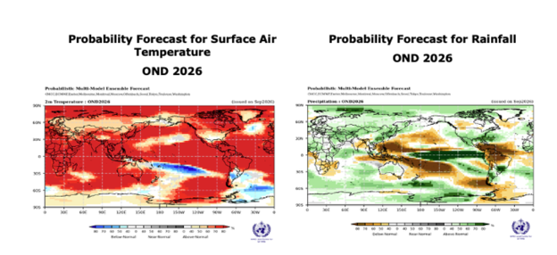
Sea-surface temperature anomalies across the central-eastern equatorial Pacific, the region at the heart of El Niño, is measured by the widely used Niño 3.4 index. This increased markedly from an average +1.6 °C above normal in June 2026 to +2.5 °C above normal in August.
For October-November-December, the seasonal average Niño 3.4 sea surface temperature anomaly is forecast to reach approximately +3.7°C, peaking around December. This is the highest since observations began and is stronger than the previous record of + 2.6 °C in November 2015-January 2016.
Other ocean basins are also contributing to the seasonal outlook. A positive Indian Ocean Dipole, a climate pattern that can strongly influence rainfall around the Indian Ocean, is expected to peak in October and then decline. The October-December seasonal anomaly is forecast at about +0.5°C.
Meanwhile, sea surface temperatures in the equatorial Atlantic basin are forecast to remain above normal, according to the Global Seasonal Climate Update.
Surface temperature and rainfall
Earth had the hottest August on record, according to monthly reports from the European Union’s Copernicus Climate Service, the US National Oceanic and Atmospheric Administration and NASA. Global sea surface temperature reached an all-time observed high in August.
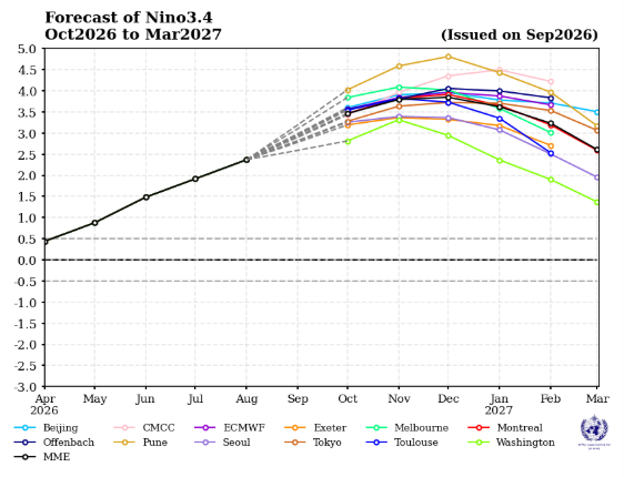
The Global Seasonal Climate Update predicts an overwhelming likelihood of above average (1993-2009) temperatures across large areas in October-December. This does not mean every location will be warmer than average every day, but it indicates a strong seasonal signal that raises the likelihood of heat extremes and heat-related impacts.
The Update also forecasts large and coherent shifts in rainfall patterns, consistent with a strong El Niño event. These signals describe where wetter- or drier-than-normal seasonal conditions are more likely; they are not a substitute for national and local forecasts.
The dominant wet signal is above-normal rainfall across the central and eastern equatorial Pacific east of the Date Line. Wetter-than-normal conditions are also more likely across the Greater Horn of Africa; parts of Central Asia and coastal East Asia; northern parts of the Arabian Peninsula; parts of North America south of 45°N; and southeastern South America.
In contrast, a broad dry signal is forecast over both the western Pacific and the equatorial Atlantic Ocean, stretching across the South Pacific to the southern tip of South America. Drier-than-normal conditions are forecast over the Indian subcontinent; southern Central America and parts of the Caribbean; northwestern South America.
WMO Action
WMO and its Members have mobilized to help minimize the impacts of El Niño across all sectors of the economy, with National Meteorological and Hydrological Services and regional climate outlook forums engaging regularly with and providing updates to decision-makers.
Recurring updates are being provided across the United Nations system and to humanitarian partners to support preparedness and risk management efforts through the WMO Coordination Mechanism.
The El Niño event and associated forecasted increase in extreme heat is one of the themes of the Global Heat Forum taking place in Bangkok, Thailand, from 6-9 October. WMO is one of the sponsors of the event, which brings together 600 experts and provides a unique opportunity to transform science into proactive, sustainable and effective solutions.
The World Meteorological Organization is the United Nations System’s authoritative voice on Weather, Climate and Water.
For further information, please contact:
- Clare Nullis WMO media officer cnullis@wmo.int +41 79 709 13 97
- Global Communication and Engagement Media Contact media@wmo.int